The Black Hills are a fascinating mountain range in western South Dakota and eastern Wyoming. The area was called Black Hills by the native Lakota because the tree-covered mountains looked black from a distance. They formed during the same orogeny that formed the Rocky Mountains, around 70 million years ago. It is basically a giant dome that uplifted a core of ancient (some 2.5 billion years old!) Precambrian rock, including layers of limestone, sandstone, and shale. Many of these layers have been eroded and weathered into cliffs, canyons, and caves, leaving a gorgeous environment to explore.
 |
| Mountain Bluebird in Custer State Park |
WIND CAVE NATIONAL PARK
Wind Cave National Park is two parks in one – one below ground, and one above. Above, a mixed-grass prairie supports bison, elk, and prairie dogs.
But the more exciting part of the park is underground. Wind Cave was the first cave to become a National Park, established by Teddy Roosevelt in 1903. It’s called Wind Cave because of the strong wind that blows in and out of the entrance, caused by the changes in air pressure outside and the cave trying to equalize.
 |
| Boxworks in Wind Cave |
It is known for the unique formation called boxwork, a honeycomb pattern of calcite fins that intersect at different angles, forming little compartments. It’s a mystery how they are formed, but one theory is that the walls have fractures caused by the stress of drying and rehydrating of gypsum, and calcite forms in these fractures.
Wind Cave is sacred to the Lakota people – it is where humans first came up to Earth. Before when the Earth was cold and dark, the Lakota were told by the Creator to stay underground in a warm, safe world while he was preparing the surface. A group of people were tricked by Wolf to come to the surface, where they soon found out they were unprepared for the harsh winters and couldn’t survive. The Creator was angry that these people disobeyed his order, so he turned them into bison. When the Earth was finally ready, the rest of the Lakota came to the surface, and the Creator told them to use the bison who would provide them with everything they needed to survive. The hole they came from was shrunk down into the entrance of Wind Cave.
JEWEL CAVE NATIONAL MONUMENT
 |
| The gorgeous formations in Jewel Cave |
Near Wind Cave is Jewel Cave National Monument, which shimmers with the world’s highest concentration of dogtooth spar. Even though Jewel cave’s 220 miles of mapped passageway currently makes it the fifth longest cave in the world, some scientists estimate that only 5% of it has been mapped! (They know this because of the estimated total air volume, which they calculate by measuring the amount of air ‘exhaled’ when the air pressure drops.)
 |
| Mmmmm... bacon...! |
Jewel Cave’s underlying limestone is thicker and less fractured than Wind Cave, so their speleothems are quite different. On our Scenic Tour, we were able to see the huge swaths of glittery dogtooth spar as well as draperies, soda straws, and even delicious looking cave bacon.
 |
| I'm a Jewel Cave Junior Ranger! |
CUSTER STATE PARK
I’ve heard people say that Custer State Park rivals the wonder of many National Parks, and it was easy to see why. We spent part of three days driving around this area of the Black Hills, and were amazed by the wildlife, geology, and stunning views. Custer is a large park with several distinct area, including a famous herd of over 1,300 bison, plus bighorn sheep, pronghorn, prairie dogs, mule deer, and even wild burros.
 |
| The eye of the needle |
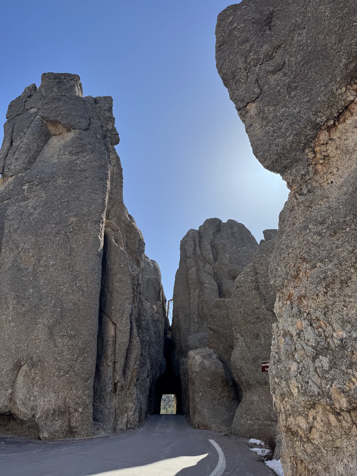 |
| The Needle's Eye Tunnel |
We drove along some of the more scenic drives of the park including Iron Mountain Road, which features fun curvy ‘pigtail’ bridges that curve over themselves and allow drivers to gain altitude quickly. It is also famous for the northbound tunnels that open up to a view of the distant Mount Rushmore. We also loved the Needles Highway, with its granite spires that pierce the sky (and fun narrow passes through the needle formations). The single-lane Needle's Eye Tunnel was so much fun we drove through it three times!
 |
| Such cool geology along the way! |
On our second day in the park, we hiked the Cathedral Spires trail - an easy out-and-back walk through the towering needle-like formations. Julia showed me the flaky mica chipping off the granite in such thin layers that they were see-through!
 |
| The aptly named Cathedral Spires |
The "crown jewel" of Custer is Sylvan Lake, a man-made reservoir created in 1881 across Sunday Gulch Creek. It was especially interesting because of the huge boulders around - and in - the water.
On our last day, we drove the Wildlife Loop Road through the rolling hills and grasslands. The best surprise was when we came upon a newly-born bison with its mother – the visitor center guide told us it was most likely just an hour or so old! Did you know? Baby bison calves, known as "red dogs" because of the color of their coat, can stand within minutes and run within hours. This baby was still wobbly on his feet, and we watched him staggering around and nurse from mom. Astonishing!
We also saw the friendly wild burros, descendants from the pack animals used by miners from the 1870s.
MOUNT RUSHMORE NATIONAL MEMORIAL
This is perhaps one of the more controversial parks in the NPS, and we definitely felt unease about it during our visit to Mount Rushmore.
 |
| Six Grandfathers, before construction. Photo: NPS |
Originally, South Dakota historian Doane Robinson conceived the idea of a carving somewhere in the Black Hills a monument to the American West, wanting heroes such as Lewis and Clark, Sacagawea, Buffalo Bill, Red Cloud, or Crazy Horse as the featured figures. It was meant to be a way to boost tourism in South Dakota, even though the mountain and the land was sacred to the Sioux and illegally taken from the Sioux Nation. In fact, the 1868 Treaty of Fort Laramie gave the Sioux exclusive use of all of the Black Hills in perpetuity.
Instead of the original American West Heroes, sculptor Gutzon Borglum decided on the US Presidents. Between 1927 and 1941, Borglum carved the 60-foot faces of Presidents George Washington, Thomas Jefferson, Abraham Lincoln, and Theodore Roosevelt into the granite of the mountain known as Six Grandfathers and named it the
Shrine of Democracy. They were not meant to be a memorial to the individual people, but rather the ideals that they fought for: the nation’s founding, expansion, development, and preservation. Mount Rushmore is meant to celebrate American history and democracy. It now symbolizes not only our national identity, but it is a reflection of the ironies and injustices that brought us here.
Regardless of my personal opinions about the monument, it is undeniably impressive. A short hike on the Presidential Trail takes you down to the base of the sculpture, where we learned about each president as well as the process of creating such an enormous sculpture. On the way, we were lucky enough to see one of the shaggy white Rocky Mountain goats that live in the area. These introduced animals were originally a gift of 6 goats from Canada who escaped their pen in Custer State Park.
Since we were staying near the area, we decided to go back to the park to view Mount Rushmore lit up at night. Upon entering the park, we walked down the Avenue of Flags where all 50 states, DC, 3 territories, and 2 commonwealths of the US are represented by their flags. At the end is a viewing platform with a majestic view of the mountain. There were way fewer people than during the day, and it was definitely impressive seeing the presidents' faces illuminated by the floodlights.
DEVILS TOWER NATIONAL MONUMENT
When people think of Devils Tower, they usually think of Close Encounters of the Third Kind. And looking at this mystifying protrusion in the middle of the prairie, it’s easy to see why people associate it with aliens. Devil’s Tower is a fascinating geologic feature whose formation is still up for debate – what is known is that it is an igneous protrusion, meaning it was an underground pool of magma that formed large columns as it cooled over 50 million years ago. Through time, the surrounding layers of sedimentary rock have eroded away, leaving just the tower.
 |
| Contemplating the boulder field |
We did two hikes around the tower, once near the base along the Tower Trail, and again along the larger circumference Red Beds Trail in order to get different perspectives of Devils Tower. Along the Tower Trail we could see up close the large boulder field made up of giant pieces of rock (some the size of a school bus!) that weathered and eroded off the tower. It was also fun to see the climbers halfway up the rock face, which gave perspective on how massive the tower truly is.
 |
| The Red Beds are aptly named! |
After a quick picnic lunch, we hiked the Red Beds Trail that circled the tower and gave us a view of the Spearfish Formation, the red and maroon cliffs that make up the sedimentary layer created around 200 million years ago. These red beds are part of the “race track” around the tower from Lakota and Kiowa traditions. In the story, a great race occurred between two-leggeds (humans) and four-leggeds (animals) to decide who would be in power. While the larger four-leggeds dominated the race, at the last moment the clever magpie darted ahead and won, giving the two-leggeds the victory and insuring the power of humans to hunt animals.
 |
| It's just so picturesque! |
We drove back towards Cedar Rapids that night and heard Ranger Ed was in town for a paleontology conference, so we met up with him for a final dinner.
 |
| Thanks, Bearded Ranger Ed! |
Overall, it was an amazing trip - early April was the perfect time to go, with fantastic weather and very few crowds. And the best part of the trip was talking to the rangers at all the National Parks - they are inspirational, passionate people who have such a wealth of knowledge. Chatting with Rangers gives such a deeper understanding of the people, places, and history of each park. I can't recommend it enough!!


No comments:
Post a Comment