GLEN CANYON NATIONAL RECREATION AREA
RAINBOW BRIDGE NATIONAL MONUMENT
An iconic photo spot in Glen Canyon is Horseshoe Bend, a huge meander of the Colorado River just downriver from the Glen Canyon Dam. The drop down to the bottom is 1,000 feet down, and its a sweeping overlook that is truly impressive. These meanders are really interesting - eventually, the rock at the start of the turn will wear away and the river will break through, creating a natural bridge at the narrow part of the peninsula of rock - like at Rainbow Bridge.


One of the more remote parks in the nation is Rainbow Bridge National Monument - the largest natural bridge in the world, located on Lake Powell in the Glen Canyon National Recreation Area. It's not easy to get to - located in a remote canyon, the only ways to get there are by boat, helicopter, or a several-day hiking trip. We took the 3.5 hour ferry ride from Wahweap Marina, through about 50 miles of Lake Powell.

It's a beautiful trip down the river, and really interesting to see how much the water level fluctuates. Around Wahweap, the lake is around 350 feet deep; closer to the Glen Canyon Dam, it reaches a depth of around 500 feet.

It was a really hot 1-mile hike up to the bridge, and although you can't walk under the bridge (in deference to the Navajo, who believe the site to be sacred), you can hike around it for different views. Its bigger than you'd think - the Statue of Liberty could stand under it! Rainbow Bridge is a sacred Navajo site and named so because of an old legend - where two brothers climbed up the rainbow to ask their father the Sun for help in saving the world. The rainbow was turned to stone as a memorial to their success.
We also stopped at the Wahweap Overlook, for an overview of Lake Powell and the Glen Canyon Dam. Gorgeous turquoise waters, and very impressive to think of the vast scope of the lake and what the dam created.
 GRAND STAIRCASE-ESCALANTE NATIONAL MONUMENT
The Grand Staircase is a huge area, encompassing much of the eroded uplifted plateau that shows the geologic progression through time. The entire staircase stretches from its highest points at Cedar Breaks and Bryce, and going downhill to its lowest point at the Grand Canyon. Because so many geologic layers are visible, numerous dinosaur fossils have been found all around the area.
 |
| http://www.nps.gov/brca/geology_grand.html |
The Staircase dominates the western part of the monument, the center section is known as the Kaiparowits Plateau, and the eastern side are the Canyons of the Escalante. This eastern section is where we spent the day hiking, doing a round trip hike through Peek-a-boo Gulch and Spooky Gulch.
 |
| Wading our way into Peek-a-boo Gulch |

This was one of the most fun and engaging hikes all of us have ever done. To get into Peek-a-boo, we had to wade through a thigh-high pool of muddy water (complete with its resident frog!) and climb up slippery sandstone rock face to get into the entrance. From there, we scrambled, crawled, and wodged (we made up that word) our way through tight wavy sandstone slits through the canyon.
 |
Squidging our way through
Spooky Gulch |
 |
| Stuck between a rock and a hard place... |
Spooky Gulch was even tighter - not only did we have to carefully maneuver our way down a ~10 ft drop into the canyon, but the slots were so small that you had to take off backpacks and squeeze and wedge your way through. At some point, the slit was so small that even my feet were too wide to fit into the cracks! It was definitely one of the most fun hikes I've ever done.
CAPITOL REEF NATIONAL PARK
The story of the Colorado Plateau has been heard in the parks all throughout the area, but Capitol Reef is one of the more geologically interesting parks. During the tectonic events of the late Triassic, the Pacific Plate slid beneath the North American Plate, causing the layers of Earth's crust above the faultline to bend and fold. The western side grew over 7,000 feet higher than the eastern, in an uplift known as a monocline, with older rocks on the west and newer rocks on the east. This 100-mile long warp is known as the Waterpocket Fold.
 |
| https://www.nps.gov/care/planyourvisit/upload/Geology-big-pictureDec15-accessible.pdf |
Throughout the park, there are 19 different geologic layers that can be seen, representing 280 million years. Erosion in the last 20 million years (with most of the canyon-cutting within the last 6 million years) has given the park the many unique shapes - from arches and spires to twisting canyons, monoliths, and domes.
 |
| Entrada sandstone spires |
 |
| Fossilized oysters |
We spent the day doing the Loop the Fold drive, going down the Notam-Bullfrog Road (parallel to the Waterpocket Fold along the Eastern side) and cutting across the Burr Switchback Trail and back around to Fruita. Along this route, there are many different landscapes, including a checkerboard sandstone mesa dotted with lava boulders, a field of fossilized oyster shells from a 95-million year old marine delta, and the steep tilt of the Waterpocket Fold.
 |
| The Waterpocket Fold: the red triangles are exposed Carmel Sandstone, layered on top of white Navajo Sandstone. |
ARCHES NATIONAL PARK
After a brief visit to Goblin Valley State Park (which has some pretty fun and interesting hoodoo formations), we're spending a few days in Moab so that we can visit Arches and Canyonlands. Because we had an early afternoon meeting with the ranger in charge of education for both parks, we didn't have time for a long hike. Instead, we stopped at several roadside attractions.

Our first stop was to Balanced Rock, a 128 foot tall sandstone formation that shows how the forces of erosion can shape the various rock layers at different rates. The top rock, Entrada Sandstone, sits on a mudstone pedestal known as Dewey Bridge Member of the Carmel Formation, which erodes much faster. Some day, the Dewey Bridge portion will weaken to the point that Balanced Rock will collapse.
 |
| Double Arch |
Our next stop was the Windows Section, where several arches can be seen close to the road. My favorite was Double Arch, which started as a pothole and grew in size until water breached the sandstone and created a hole in the ceiling. At the same time, the 'walls' of the rock were also eroding, creating the double arches.

Nearby are North and South Arches, and Turret Arch.
 |
| South and North Arches |
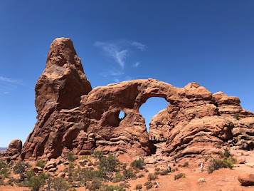 |
| Turret Arch |
After meeting with Rangers Heidi and Michael, we decided to check into our hotel and grab dinner. The hotel, Adventure Inn, is 100% solar! Makes us feel good that we're spending 3 nights here!

 |
| Delicate Arch |
 |
| Delicate Arch from the lower viewpoint |
In the early evening, we decided to hike up to Delicate Arch before going to the evening ranger talk. It was still hot and crowded, but the view from the top was fantastic. We also went to the lower viewpoints, and it was amazing to see how far away (and how isolated) Delicate Arch is.
The ranger program for the night was actually quite different from the ones we've had in the past - about cars in the parks and the changes (and, sometimes, the destruction) caused by putting in motorways. The ranger seemed to pose the problem, but let us talk about it and didn't give us a solution. On the one hand, having roads and accessibility allows more people to enjoy the park, but it does bring in more pollution, crowding, and puts roads through the wilderness.
 |
| Balanced Rock at 3AM (After moonset) |
 |
| Balanced Rock at midnight, with a bright moon |
That night was the first clear night we'd had, so we were excited to get the chance to stargaze. The only downside was that the moon, which is less than a week from being full, was setting at 2:30 AM - meaning it was fairly bright out even though we were deep inside the park. We stopped first at Panorama Point, which gave us a fairly unobstructed view of the night sky, and we tried our best to block the moon and take pictures. Without any background formations, it was hard to make anything look good, so we moved to Balanced Rock for another try. The moon was still fairly bright so we took a nap, then tried again at around 2:45. Our skills and equipment weren't great, but it was still fun getting to see the Milky Way.
Two days later we returned to the park, mainly because we got guided ranger tour tickets, but it was nice to have more time to hike. We got an early start and headed out into Devil's Garden, taking the Primitive Trail. There are many famed arches along this route, and because it is a bit more difficult with some steep slopes and some rock scrambling, there were much fewer people to share the trails with the further along we got.
 |
| Landscape Arch |
The first major arch we got to was Landscape Arch, a 306 foot long, really thin arch that looks like it is about to collapse. In fact, a 60-foot long slab fell from it in 1991... and every year, as more precipitation seeps into the sandstone and the freeze-thaw cycle weakens the rock, the closer it is to its end.
 |
| Partition Arch |
 |
| Hiking along the fins on the Primitive Trail |
We continued along the trail, stopping at the various arches, then took the Primitive Trail back around to the start. It was fun scrambling around on the fins and canyons, and seeing the different stages of arch formation (and collapse).
 |
| Entering the Fiery Furnace |
 |
| Had a few tight spots... |
After going back to the hotel for a bit of a rest, we went back into the park for our Fiery Furnace hike. This area requires either a permit or a ranger-led tour, so we were lucky to get spots on one of the 14-person hikes. And it was definitely worth it - the area is well protected and much quieter than other parts of the busy park, and there are many canyons, arches, and fins in a small area. There were lots of dead-ends and no trails or markers, so I'm glad we had a ranger guiding us. And despite the name, Fiery Furnace is more sheltered from the sun and has a nice breeze blowing through the canyons, so it was much cooler inside!
 |
| Great views inside Fiery Furnace |
CANYONLANDS NATIONAL PARK - ISLANDS IN THE SKY DISTRICT
We got a rather late start the next morning (since we didn't get to bed until around 4AM), so we had a bit of a leisurely day at Canyonlands. After stopping at the Visitor's Center for Gem and Anil's Junior Ranger Badges, we set off into the park.
 |
| Mesa Arch |
Formed at the confluence between the Colorado and Green Rivers, Canyonlands is divided into three main districts. To the west, the Maze is more rugged and difficult to get to - it's a backcountry area with no paved roads. To the east is the Needles District, which we visited about 2 weeks ago, is named for the many finger-like spires throughout the landscape. And at the top of the 'Y' is Islands in the Sky, the mesa that looks out over the entire landscape.
The scenery here is spectacular, with huge mesas, canyons, and buttes that are unlike anything I've ever seen. We stopped first at Mesa Arch, with gave us our first view of the surrounding valley. The arch itself was right on the edge of the cliff, with a great window to the landscape.

And the landscape is so interesting! It's like a reverse-topographical map, with so many layers, leading down into canyons formed by the two rivers and their tributaries. But its much shallower but vaster than the Grand Canyon. It is really fascinating to see how differently this area looks, since it too was created by river erosion (the Green and Colorado Rivers also shaped this area).
From Mesa Arch we drove down to the Grand View Point, stopping at various overlooks to see the canyon. The Grand View Point tapers to the junction of the 'Y', looking both at the Colorado River and the Green River. If not for a huge mesa right at the tip of the overlooks (one of the "Islands" of the Islands in the Sky), you'd be able to see the actual Confluence, where the rivers meet.
On a side note: do you know the difference between a mesa and a butte? A mesa (Spanish for 'table') looks more like a table - wider than it is tall. A butte is taller than it is wide - like a bar stool.
 |
| To the left is the Colorado River, to the right is the Green. The mesa in front blocks the view of the actual confluence. |
Even without being able to see it, the views were spectacular and well worth the slightly nerve-wracking hike out to the tip of the Point.
 |
| Gemma, getting that all-important epic shot! |
 |
The Grand View Point trail,
right at the cliff's edge |
 |
| Love that the Colorado eroded a canyon into a giant dinosaur footprint! |
 |
| Aztec Butte |
On our last day in Moab, we had a final morning in Canyonlands. We were all still really curious about the landscape, so we made it a point to make it to one of the ranger talks on geology.

Before that, we decided to visit Aztec Butte, a short hike to see some Ancient Puebloan granaries and views from the top of the butte. It was a surprisingly steep hike up the slickrock, but it had some great views across the canyon.
The final hike was to Upheaval Dome, a curious crater with a large dome in the middle, that has puzzled geologists. Some believe it was created by a salt dome collapsing underneath, but we preferred the theory that a giant meteorite vaporized on impact, creating the crater. Whatever its origins, it has curious patterns of rings when viewed from above, and from the overlooks, you can see the domes and spires that protrude from the inner dome.

CAPITOL REEF NATIONAL PARK (Part II)
We returned to Capitol Reef for the day, to meet with Ranger Lori and to see the Scenic Drive. We started by going to the Gifford House to see if they had any fruit (no, since they sold out pretty much after 5 minutes of opening), though we did pick up two more pies. We met with Lori, who had the best reaction to the VR machine - and who was really supportive in our project and what we were doing.
 |
| Ranger Montana, picking apples |
 |
Ranger Amanda even gave us some
just-picked apples! |
She also facilitated our meeting with Amanda, the head of the orchards, so that we could get footage of the trees and fruit-picking. Amanda and Montana took us into the Jackson Orchard, where we were able to get some footage (and a bit of a taste!) of fresh apples picked from a tree. Lori's idea was that most kids don't know where their food comes from, so seeing the experience of picking an apple would most likely be new to many people.
Before meeting Amanda, we went up to Petroglyph Panel to see the 800-1000 year-old petroglyphs. They were further away and harder to see than some (eg Newspaper Rock), but the design was different (having been done by the Fremont Culture, contemporaries to the Ancient Puebloans who were South of the Colorado River).
 |
| Capitol Dome |
We then hiked the Hickman Bridge Trail, with views of the Capitol Dome (which Capitol Reef is partially named).
 |
| Hickman Bridge |
 |
| Scenic Drive was truly scenic! |
Probably the most popular thing to do at Capitol Reef is to see the Scenic Drive, which goes past Fruita through some really amazing landscapes.

 |
| Capitol Gorge |
We took the dirt road out to the end of Capitol Gorge, then hiked a bit our onto the wash until we saw the old Pioneer Register - a huge rock wall with old graffiti, where pioneers from the late 1800s - early 1900s carved their names.
 |
Look for the small caves at the base of the cliff -
old uranium mines! |
Because there was thunder and dark skies, we worried a bit about getting trapped out on the wash and turned back early. We did get a chance to go down Grand Wash and see some of the old uranium mines, before heading back to Fruita where we had more pie. Delicious!
BRYCE CANYON NATIONAL PARK
This morning we were lucky to meet up with a friend of a friend Adam, a professional hiking guide, and his wife Shauna, a ranger at Zion, who came into Bryce and joined us to hike the Navajo/Peekaboo loops. Adam leads hikes around the southern Utah area, but since it is the low season (too hot for most people, apparently!), he was excited to get out and hike.
 |
| Wall Street |
 |
| Bryce Amphitheater |
We started down into the hoodoos via Wall Street, a steep switch-back trail into a canyon with high, straight walls that leads to some incredible views. Bryce Canyon is actually inaccurately named - it isn't a canyon (which is formed by a river between two walls), but instead a series of amphitheaters. The top of Bryce is a plateau, formed by soft limestone of the Pink Member of the Claron Formation. As slightly acidic rainfall dissolves the limestone, it leaves lumpy, bumpy sides. Fins form out of the cliffs, which may eventually form windows due to the freeze-thaw process, and when the windows collapse, individual hoodoos are formed.

 |
We completed the "I Hiked the Hoodoo
Challenge"!! |
The tops of the Bryce Canyon hoodoos are capped with dolomite, which are more durable and helps protect the weaker limestone underneath. But eventually, the hoodoos will also collapse, forming the rounded hills known as badlands. At Bryce, hoodoos erode at the rate of about 2-4 feet every 100 years, so in about 3 million years it will reach the Sevier River.
 |
| Wall of Windows |
 Getting to hike down among the hoodoos was a great experience, allowing us to see upclose what the hoodoos looked like. Every turn brought us a new vista, and halfway down the Navajo Loop Trail we cut over to do the Peekaboo Loop. Towards the end, it started to rain but we just happened to be by a large alcove with benches, so we waited out the downpour. In the meantime, we even saw a rattlesnake!
After the rains, the weather was much cooler and the rest of the hike was pleasant - even the steep uphill back to Sunset Point, where we had a nice view of Thor's Hammer.
 |
| Thor's Hammer |
We had a picnic pizza lunch with Adam and his family, then went to the visitor center. The ranger suggested we drive out to Rainbow Point at the far southern end of the park, so we did the Bristlecone Loop trail to see the views at the end of the park and to see the Bristlecone pine trees.
The next morning, we did the Fairyland Loop trail, an 8-mile hike that goes down into the Bryce Amphitheater on the North side, as well as going along the plateau rim. Since it is one of the longer, harder day hikes, there weren't many people on the trail.
 |
| The start of Fairyland Loop - entering Bryce Amphitheater |
For much of it, we had the peace and quiet to enjoy the hoodoos on our own. After stopping for a snack at the Tower Bridge, we hiked back up to the Rim and started back to Fairyland Point when the long, loud rumblings of thunder started, We were about half a mile from the car when it started hailing, so our last bit of hike was actually a run... a fun way for Gem and Anil to end their Parks trip!
 |
| Exhausting trip for Anil! |


 The geology of the area is pretty interesting - 270 million years ago as the tectonic plate movements were still forming our current continents, there was another plate between the current Pacific and North American Plates (that now form the slip-fault that is the San Andreas Fault). Before that, the Farallon Plate pushed up against the North American Plate, but as it was made of a more dense material, it subducted under the North American. As it did so, it heated the rocks and formed magma which then began bubbling up towards the earth's surface. It eventually cooled and cracked in parallel horizonal and vertical planes, but never broke the surface (and are thus considered plutonic rather than volcanic.)


 As we drove into Sequoia, we could easily see the smoky effects of nearby forest fires. The vistas were muted, and visibility was poor even from the top of Moro Rock, a large 6,725 ft high granite dome that can normally give views of nearly the entire park. We nonetheless hiked to the top, taking the impressive carved stairs that were built by the CCC in 1931.


 Kings Canyon is known for three main areas - Grant Grove, where another forest of giant sequoias can be found (including the Nation's Christmas Tree, the General Grant Tree), Cedar Grove (at the end of the road at the bottom of the canyon), and thousands of acres of high Sierra wilderness, where the only access is by foot. We drove down to the end of the Kings Canyon Road, stopping for a hike around Zumwalt Meadow.


