Overnight, we sailed into Panamanian waters. Our first stop was to Guna Yala, once known as the San Blas Islands, an archipelago of over 300 islands. 50 of these are inhabited, and we spent the day on Cayo Holandéses to enjoy the crystal waters, learn about the locals, and seeing some of the traditional houses. We tried a little snorkeling, but spent most of the time just enjoying the beach.
The Guna are known for their handmade textiles known as molas, and there were several vendors with their samples hanging on the beach. After lunch, we enjoyed a music and dance presentation from the Guna - many of their instruments were made from locally-sourced materials, the most interesting of which was the flute/whistle made out of crab claw.
We also went on a walk around the island, where we visited one of the palm-covered shacks that was the home of one of the locals. A small kitchen sat in one end, and the rest of the shack was filled with hammocks – an important part of the Guna culture. Guna babies are immediately placed into hammocks upon birth, and when someone dies, they are wrapped in a hammock to be buried.
Our next stop was the historical town of Portobelo, “beautiful harbor,” allegedly named by Christopher Columbus the moment he set eyes on it in 1502. The town was an important port for the Spanish, who were bringing treasures across the Atlantic. Because of this, there are several Spanish forts protecting the harbor. Throughout the 15th, 16th, and 17th centuries, the town was besieged and captured multiple times. It was also captured by Admiral Vernon during the War of Jenkins' Ear, which became so popular that many places in the UK were named after the town - like the famous Portobello Road in London.
The Cristo Negro
Cruisin' around town
Portobelo is also famous as the destination of a yearly pilgrimage to see the Cristo Negro – the “Black Christ” statue that was found on the shores of the harbor. Every year, people come from all over Panama to visit the church and the small town of less than 5,000 swells to over 100,000. There are several legends about the Black Christ, including one where a ship trying to leave port was swept back 7 times by a storm. Finally the sailors threw overboard the box containing the statue, which caused the storm to subside and the ship to leave.
On the ground floor of the Real Aduana de Portobelo - the Royal Customs House, we visited the museum exploring AfroPanamanian history and culture. We then watched the “Congo Carnival” presentation, showcasing the traditions of the Cimarrones, the former African slaves who escaped the Spanish to form their own colonies. In the 1570s, the Cimarrones allied with Sir Francis Drake and the English to defeat the Spanish. ((Side note, Drake was buried at sea in a lead coffin in Portobelo Bay, and we sailed by Isla Drake at the mouth of the harbor.))
The inside-out clothing of the men represent the modification of clothing made by their slave ancestors; the rope belt held beheaded dolls, representing the violence done to the slaves. Their faces are painted black, just like their ancestors camouflaged themselves as they escaped through the jungles. The red-and-black-dressed diablos (devils), represent the evil Spanish slave owners who were always abusing the slaves.
Isla Drake, at the mouth of Portobelo Bay
In the 1570s, the Cimarrones allied with Sir Francis Drake (the English explorer who circumnavigated the globe) to defeat the Spanish. On a side note, Drake later died of dysentery in Portobelo Bay and was buried at sea in a lead coffin. It has never been found, but treasure hunters continue to search the sea floor to this day. Perhaps as we sailed out of the harbor, we sailed over Drake's remains....??
Each of the green flags is a ship!
After reboarding the ship, we continued southwest to the Panama Canal. As we drew closer, we could see dozens of huge cargo ships on the horizon. They were all waiting for their turn to cross over to the Pacific. Once we reached the mouth of the Atlantic entrance, our timing to cross was in the hands of the Panama Canal Authority.
A quick and dirty* history of the Panama Canal *100 million cubic yards of dirt, to be precise...
Ever since the Spanish began exploring the world, they had a desire to easily transport goods from Asia to Europe.
Did you know? If you cross the Panama Canal from the Atlantic to the Pacific, you actually travel southeast!
When Balboa first crossed Panama in 1513, he realized it was a narrow strip separating the Atlantic and Pacific Oceans - the perfect place for a shortcut. But back then, they didn't have the means or knowhow to do it. Until the canal was built, the only way across was sailing around South America – a perilous and lengthy journey. After the Gold Rush in California, a railway was built across Panama in 1855 to carry passengers and freight from the East Coast to the West. But transferring a big load of goods was really difficult - a canal would be much better.
The French builder of the Suez Canal, Ferdinand de Lesseps, first tried to build a canal in 1881. But he planned it the same way as the Suez – by digging a trench across the entire isthmus of Panama. The Suez is flat and dry, but Panama has much more challenging terrain – thick jungle, mountains, heavy rains causing flooding and landslides, and mosquito-borne diseases were only some of the challenges that the French faced. After 8 years, 22,000 deaths, and $287 million dollars, the French gave up.
During this time, Panama was a Colombian territory. The US first tried to acquire rights to the canal by negotiating a treaty with Colombia, and when it was rejected the US helped Panama revolt and gain independence in November, 1903. Three months later, the US was granted control of the Panama Canal zone for $10 million dollars by the new Panamanian government, and construction began soon after. The canal finally open in 1914.
Two main changes happen that made the US successful – the engineering design changed to a lock system, and epidemiologists realized mosquitoes were the cause of yellow fever and malaria.
Rather than digging 55 kilometers all the way across the isthmus of Panama, the US decided to build a lock system. They would create a large artificial lake in the middle of the country by damming the Chagres River. Lake Gatun would become the largest artificial lake in the world, and would save a lot of digging. Using locks, ships would be raised from sea level up 85 feet to lake level, sail across the isthmus, then get lowered back down to sea level on the other side by another series of locks.
Excavation of the Culebra Cut, April 1907
The one snag was Culebra, the mountain range running across the country containing the Continental Divide. To access the Pacific from Lake Gatun, a valley needed to be excavated from the 210 foot summit. When they finished, over 100 million cubic yards of material was removed.
The locks are completely gravity-powered, but each lock fills in around 10 minutes – the water from Lake Gatun flows into each chamber until the level matches the next higher lock. Only when the water levels match do the lock gates open. Unfortunately, this year’s El Niño has caused a massive drought, and the number of ship crossings have been reduced from 36 to 25 (and in February it will drop down to 18!). In the waters outside the canal, dozens of vessels sit, waiting their turn in the queue. Just a few weeks before we crossed, a Japanese ship paid almost $4 million dollars to jump the line and cross.
So if your goods start costing more, don’t be surprised.
Because our ship had reserved a crossing time over a year ago, we were able to cross not long after we arrived. The technical maneuvering of the canal means every ship requires a trained pilot to board, so we waited a few hours for ours to arrive. It was a fun time playing mah jongg with our new friends Joe from Texas, and Karen from Delaware!
A rainbow welcome into the Panama Canal!
We entered the canal past the city of Colon, sailing under the Atlantic Bridge to get to the Gatun Locks. A series of electric locomotives, called mules, helped steer us and keep us from running into the lock walls.
The set of 3 locks would raise us 85 feet to the level of Lake Gatun. Each lock takes over 26 and a half million gallons of water to fill, and the entire system is filled only by gravity from the lake.
It was fun watching the lock fill, which only took about 10 minutes!
We sailed into Lake Gatun, where we spent the night. The next morning, we headed onto one of the islands in the middle of the lake, Barro Colorado. It was once a hill overlooking the Chagres River, which turned into an island when the valley was flooded. The new island became a natural laboratory to study tropical ecology and island biogeography, and is managed by the Smithsonian Tropical Research Institute.
Look at the sexual dimorphism between this orbweaver and her little suitor!
We spent the morning exploring the island, hiking through the rainforest while looking for wildlife. Immediately upon disembarking, there was a sloth hanging on the handrail near the dock, but he was a bit too far away for us to get a good look. The hike around the island gave us a nice overview of the rainforest ecosystem - there were a few too many people in the group for us to see much wildlife, but it was a nice way for people to see what rainforest plants and vines are like, and we did see a few birds, an agouti, frog, and lizard.
We also tried hard to see the howler monkeys that we could easily hear, but they were foraging in thick trees and we only caught brief glances.
Back on board, it started pouring rain. It was raining so hard that we could see the island, maybe 50 yards away! So it was a good thing we had a free afternoon while we waited for our next pilot to board and guide us through the next set of locks. We spent a nice afternoon teaching mah jongg to our new friends Karen and Joe. It was evening when we reached the Pedro Miguel Locks. With the light rain and heat lightning lighting up the sky, we didn't stay outside for long.
The next morning, we said farewell to the NG Quest at the dock in Balboa, once the capital of the Panama Canal Zone controlled by the United States. Originally we thought we'd go directly to our hotel (or get transferred to the airport with others who were leaving), but there was a bonus city tour/brunch that would deliver us to our hotel. Hooray! It was raining, so we had a very wet tour around the city. The bus took us down the Amador Causeway, the 3.7 mile long road constructed from rocks extracted during the digging of the canal and now connecting the mainland with four islands in Panama Bay. As we drove back, we saw a crocodile swimming in the waters!
We then headed to Casco Viejo, Panama City's old historic district. Casco Viejo was built in 1673 after the original city was burned down by pirates, and many of the buildings were reconstructions after various fires destroyed the previous ones. We spent most of the time in and around the main square (mostly because it was still pouring rain, and our shoes were completely soaked).
The flat arch in the Convento de Santo Domingo
We ventured into the Metropolitan Cathedral in the main square, then wandered the cobblestone streets to see the flat arch in the Convento de Santo Domingo, and brunch at La Compañía - the hotel next to the former Jesuit church-turned-university. We weren't actually very hungry since we were so well fed on the ship, so instead we had a quick wander around town.
Giant ground sloths at the Biomuseo
We then transferred to our hotel, then headed to the Biomuseo to meet up with our new friends Emily, her mom, and her aunt Karen (who was our mah jongg parter on the ship). The Biomuseo is a funky, colorful building along the Amador Causeway designed by Frank Gehry. It's a lovely museum highlighting the amazing biodiversity of Panama, so it was a nice way to spend a few hours.
Mi Pueblita
The next day was a full-day tour of Panama City. We started at the base of Ancon Hill, which was a bit too much hiking for my parents, so instead we toured Mi Pueblita - replica buildings with displays of European colonial housing, traditional Panamanian clothing (with women's pollitos), and coastal Caribbean village. It gave a nice, albeit quick overview of the history of Panama.
We then drove over the Bridge of the Americas and stopped at the viewpoint known as Mirador de las Américas.
There is a great view of the canal and bridge, as well as a lovely memorial dedicated to the history and hard work of Chinese-Panamanians. The first Chinese came to Panama in 1852 to help build the transcontinental railway (an endeavor partly spurred on by the California Gold Rush - when many East Coasters were trying to quickly get to the West Coast). Panama now has a huge Chinese population - who knew?!
As an added, unexpected bonus, our guide drove us along the coast of the western side, where we could see the wide tidal flat exposed during the low tide. According to our guide, it's so shallow that you can walk to the nearby islands during low tide. We drove to the nearby town of Veracruz on the Pacific Coast, where he bought us bananas from a roadside vendor since my dad was wondering why we had seen so few bananas on our trip!
On our way back downtown, we drove through various different neighborhoods of the city, including the slums known as El Chorrillo - home of boxer Roberto Durán and hometown of former dictator Manuel Noriega. This neighborhood is more rundown than others we had seen, with crumbling buildings and graffiti on the walls. It was also interesting to see a heavy police presence around the city - there is no military in Panama - but they were preparing for a controversial supreme court ruling* that was supposed to have come in on Friday.
*The verdict came out the day after we left Panama - and it was good news. Corrupt copper mine contracts were ruled unconstitutional, but many believe the courts are equally corrupt, so the country was ready to shut down in protest. It's a victory for the environment and for the people - hooray!
Since we had seen much of Casco Viejo the day before, we didn't spend much time in the old city. We did stop at the San José Church to see the golden altar - which once had been painted black to hide it from the maurading English pirate Henry Morgan in 1671.
What was actually more interesting to me was the nondescript back room, which held an enormous diorama of the life of Jesus. (I particularly like the fact that they clearly bought random statues to populate it, so upon close inspection you can find a guy in colonial garb holding a rifle).
After a quick stroll around the Plaza de Francia (the original town square, now dedicated to France's involvement in building the Panama Canal), we drove back down Amador Causeway. Today was a much nicer day, so having lunch by the water was a lovely way to spend our last day!
Finally, we stopped at the Mirador visitor center for one final view of the Panama Canal Locks. Unfortunately the main museum is closed for a long renovation, but we did see a nice IMAX film explaining the entire history and engineering of the canal, then went out onto the viewing decks to watch a ship going through the canal - but it was sooooo incredibly crowded, and a view from the ship was honestly much better.
Still is was a nice way to end our time in Panama!
Cartagena de Indias, or Cartagena, was once a strategic port on the Caribbean Coast for colonial Spain - from here they would ship goods (mainly gold, silver, and slaves) between the Americas and Europe. Because of its economic and strategic importance, it was constantly attacked by pirates. The charming walled city and fortress of the old town, built by the Spanish in the 1500's as protection against French and British buccaneers, is now a UNESCO World Heritage Site.
* * * * *
Did you know? A pirate is someone who commits robbery or criminal activity at sea and a privateer is a privately own ship that is authorized by a government to attack and capture enemy vessels (and a corsair is a French privateer). All the pirates and privateers in the Caribbean during the 17th and 18th centuries were known as buccaneers.
* * * * *
Cartagena was also the site of one of the battles of the War of Jenkin’s Ear – a fight between the British and Spanish in the 1740’s after Captain Robert Jenkins’ ear was severed by the Spanish Coast Guard while they were looking for loot. The insulted British used it as an excuse to wage war, since they wanted to gather power in the Caribbean for the slave trade. Most notably, soldier Lawrence Washington returned home from that war and named his estate after his commanding officer, Admiral Edward Vernon. After Lawrence Washington's death from tuberculosis, Mount Vernon became the home of his younger brother – the future President George Washington.
We boarded the National Geographic Quest after a short bus tour around the city. It’s a luxury ship with room for around 100 passengers, but there were only around 50 of us – making it comfortable yet interesting. I shared a room with Lisa, a retired teacher from Iowa, which was nice since we have similar travel styles. (But honestly, I spent very little time in the room!)
After settling in, we had dinner on board and explored the ship. As we sailed out of Cartagena, the seas started getting rocky so we all went to bed early. 🤢
Early the next morning, we loaded onto the Zodiacs for our first excursion. We were stopped in the Gulf of Morrosquillo at the Reserva Natural Sanguaré. A former livestock farm, the reserve has been reforested and is dedicated to conservation and education. It was raining when we reached the reserve, which unfortunately meant most of the birds we were hoping to see were hiding out.
But luckily it also meant fewer mosquitoes and sand flies, and after an hour, the rain stopped and several interesting species showed themselves. The chestnut-winged chachalaca is endemic to the area - meaning it is only found in this area of Colombia and nowhere else in the world - and we saw several as we toured the grounds.
Look at that crimson crest!
We also saw, among others, a red crowned woodpecker, crimson-crested woodpecker, russet-throated puffbird, and several dangling oropendula nests.
The excursion ended with a local music and dance presentation, and an explanation of the different influences of various cultures on Colombian music. Drums came from the African slaves, the wooden flutes and maracas from the indigenous tribes, and the flowing dresses from the Spanish.
After lunch, we loaded back onto the Zodiacs and headed into the Bay of Cispatá. There, we transferred into panga boats to explore the mangrove estuary at the mouth of the Sinú River. Local fishermen accompanied us and helped to spot the various wildlife.
The mangroves, with their extensive root system, is an important part of the ecosystem - they help to protect the land from erosion, as well as providing shelter for many types of wildlife. We saw several blue heron, tricolored heron, egrets, white ibis, pelicans, and frigate birds.
GO, little guy, GO!
The locals are trying to help the American Crocodile population, so they raise them and brought a baby for us to release back into the wild. I got do the release!
Because of its location on the Caribbean, Colombia has had many foreign influences and waves of immigration. This is reflected not only in the music, food, and dress, but in the culture and architecture seen throughout the region. The next day, we went to see Santa Cruz de Lorica, a town on the Sinú River that was influenced by people from France, Belgium, England, Syria, and Lebanon.
Just outside the market flows the Sinú, with fishermen casting their nets while large white herons lurk overhead, waiting to steal a fish.
We walked through the Mercado Publico, where the pungent aroma of different spices hung thickly in the air. The building is a mix of Republican and Arabic architecture, and is the most iconic building in this heritage town.
We also visited an Arabic influenced home, seeing the geometric tiles, arches, high ceilings, and ventilation common in the Middle East. In the central square, along with visiting the main cathedral, we saw the mural honoring Colombian writer Manuel Zapata Olivella.
Trying to cross the streets in town, we could see how prevalent motorcycles are. In Colombia, motorcycles and motorbikes are really popular – this started during an economic downturn, since motorcycles are cheaper than cars and an easy form transport. People would also use them as a quick taxi service. With so many motorbikes, the government decided to make a law that people could only bring their bikes out every other day, depending on their license plate number. But this just caused people to buy a second bike. In Lorica, there is an average 5 bikes per household!
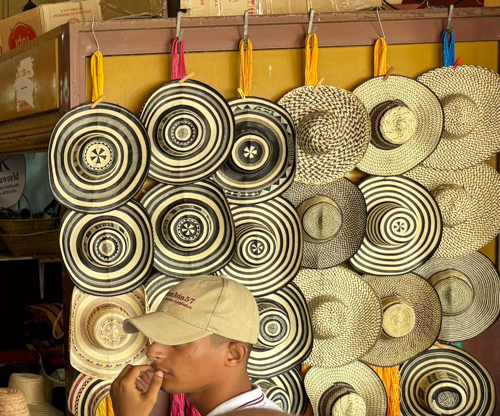
After lunch, we traveled to Tuchín, the small town where Colombia’s traditional cane hats – the sombrero vueltiao – originated with the indigenous Zenu people. Over 1,000 hats are produced daily in this town, and the craft is passed down from generation to generation.
We learned about each step of the process: collecting and preparing the cana flecha (the arrow grass that grows on the banks of the Sinu River), dying the fibers, and weaving them into the hats. The number of fibers in each braided strip determines the quality of the hat – the more fibers used, the finer the weave and the more expensive the hat. Even kids are part of the process.
The friendly faces of Tuchín
Dance by the local Tuchín children showing the importance of weaving
That night, we continued sailing southwest, to the border between Colombia and Panama.
On the Caribbean coast lie two remote villages, La Miel on the Panamanian side, and Sapzurro across a hill in Colombia. There are no roads getting to these villages so there is little tourism; the only access is by plane or boat. But it's a geographically interesting place, because you can easily hike over a small ridge from one country to the other.
Straddling the Panama/Colombia border
We schlepped up the slick, 250-step hill to cross the international border from Panama to Colombia. (Spoiler alert, no customs or immigrations were waiting for us at the top). From the crest, there was a lovely view of the Caribbean. The path was slippery with wet moss, so I was really proud of my parents who made it without problems!
Panama on the left, Colombia on the right!
Down onto the Colombian side, we hiked into Sapzurro - a tiny town settled by Afro-Colombians. Enjoying an ice cream on the unspoiled and idyllic Sapzurro beach was in intellectual contrast from our next stop - the nearby village of Capurganá. Capurganá is the jumping off point for most of the migrants headed into the thick jungle known as the Darién Gap. The Darién region is infamous – one of the most dangerous places of the world.
The Pan-American Highway, a series of roads running from Prudhoe Bay in northern Alaska to the tip of Ushuaia, is the world’s longest “motorable road” – except for a break of 66 miles between Panama and Colombia known as the Darién Gap. There is no road through the Darién, and the jungle is thick and marshy and filled with rivers that often flood. On top of that, rapes and robberies are common; dead bodies are left where they die. Even though it is considered “impassable,” thousands of migrants attempt the 6-day 66 mile trek in their attempt to reach the United States. I had no idea that most of these people come from Africa, the Middle East, and Asia – they do so because Colombia has no visa requirements, and many of these migrants are unaware of the perils of the crossing. They come unprepared. Many think the US lies just on the other side of the gap, not realizing they still need to trek through Central America and Mexico.
Journalist Richard McColl, who was one of the experts accompanying us, had spent lunchtime in town trying to talk migrants and hear their stories. The mafia running the migrant camp wouldn't let him in to talk to anyone, but he did interview two men in town who had recently arrived from Togo and who were preparing to start their journey.
As we pulled into the pier in Capurganá, we could see several boats and many migrants sitting along the waterfront. The town itself is a quaint little seaside resort, with cheerfully colored buildings and oceanside cafes. It seemed like the antithesis of what we now knew was about to be faced by the thousands of migrants passing through here.
The interesting architecture and vibrant buildings of Capurganá
Boats approved by the Colombian Navy bring these desperate people from Necocli (across the bay) to Capurganá, where they bottleneck at the migrant camp while they wait to cross the Darién. While the Red Cross registers all migrants (to keep track of the numbers), the camp and access is controlled by the local mafia, Clan del Golfo. It costs between $50 to $150 for the privilege of the trip. According to Doctors without Borders, almost 500,000 people will attempt the crossing this year - including tens of thousands of children.
We walked around the town, avoiding the dangerous western side near the jungle where the migrant camp was located. We then headed to the local school where the schoolchildren gave us a performance of both traditional and ballet dance.
Dominoes is a very popular 'sport' in Colombia
Hearing the stories and seeing the different aspects of Colombia gave me a much better understanding of the rich culture, fascinating history, and impossible challenges that face this country.