This summer I decided to stay in the US - because while I'm disappointed, concerned, and upset about the direction the country is going, I needed to remind myself that there are still good things to be found in some slightly disturbing places. I started my trip in El Paso, Texas, where I picked up my rental car and immediately drove out into New Mexico.
WHITE SANDS NATIONAL PARK
It was around 2:30 pm and ~94° when I got to White Sands National Park, located in the Tularosa Basin in the northern Chihuahuan Desert . White Sands encompasses the largest gypsum sand dunes in the world - about 225 square miles. Most sand dunes are comprised of silica, but the unique geography of this area made it the ideal place to develop gypsum dunes.

About 250 million years ago, this area was covered by the Permian Sea, which deposited water-soluble gypsum into the ground. 70-30 millions years ago, tectonic activity pushed up this ground to form the San Andres Mountains to the west and the Sacramento Mountains to the east. During the wet weather of the Ice Age, gypsum was carried down into the Tularosa Basin and trapped there, forming Lake Otero - a huge lake that covered most of the basin. When the water evaporated, it left gypsum crystals (in the form of selenite) on the ground. The movement of wind and water breaks down those crystals into small grains of gypsum sand. The formation of the sand dunes really only began around 10,000 years ago.

Gypsum sand dunes are interestingly different than other sand dunes. They don't hold heat like regular sand, so it's cooler to the touch (but the glare is absolutely blinding and you basically have to shoot photos with your eyes closed and hope for the best). The sand behaves differently as well, since it dissolves in water and hardens, increasing wind resistance. This also means plants can grow faster and not get buried by the dunes.
One of the most interesting things to observe is the rather quick adaptation made by the animals living in the dunes. Because lighter colored animals can blend into the sand and escape predation, animals such as the bleached earless lizard, the Apache pocket mouse, and several crickets and spiders have basically turned white.
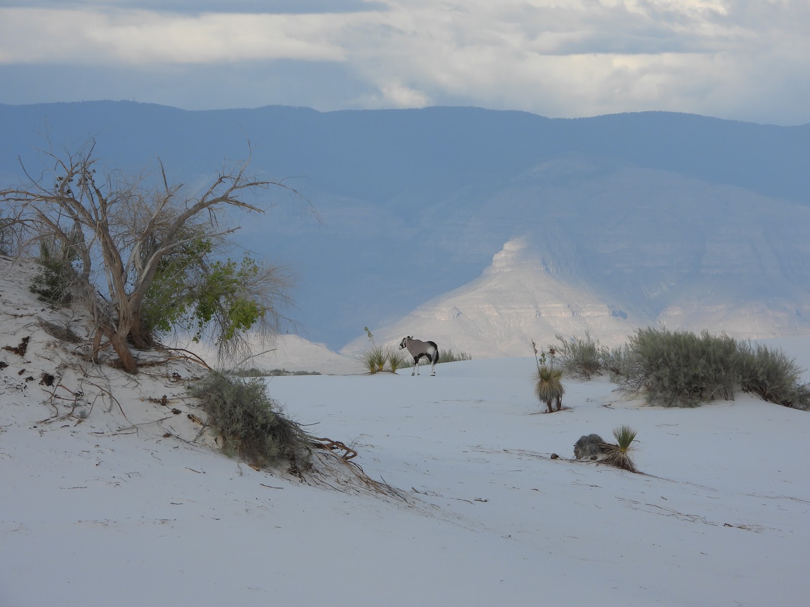 |
| Cool to see an oryx, but not cool that they are there... |
Another interesting (and slightly disturbing) thing you can find in White Sands is... the African Oryx.
Whaaaa??? you may ask. Well, in their infinite wisdom, the hunters of New Mexico decided they need something fun to kill, so about 50 years ago they released 90+ oryx in the White Sands Missile Range. The thought was that the population would stay around 500-600 animals and remain in the Tularosa Basin, but hmmm. Animals actually wander around. With no predators (except the hunters) and an abundance of food, the population is now more than 5,000. And even though a million-dollar fence was put around the National Park, a handful of oryx are still inside, trampling the fragile environment and outcompeting native species for the limited resources.

Hiking around White Sands during the day was hot and blinding so I didn't go too far, but after checking into my hotel and grabbing some dinner, I returned to the park for the sunset stroll later that evening. With the sun going down, it was much cooler and easier to see without the bright glare. We could also see flashes of lightning from the approaching thunderstorm, which made for a lovely and dramatic sky.
GUADALUPE MOUNTAINS NATIONAL PARK
The next day, I drove to Guadalupe Mountains National Park, home of the highest point in Texas - Guadalupe Peak (8,751 ft). This park is isolated and unassuming - while it isn't as visually stunning as many of the other parks I've been to, there's some pretty interesting geology and history behind it: namely, the mountain range used to be an underwater tropical reef!
 |
Shell fossils along the
Devil's Hall trail |
During the Permian Age (250 million years ago), this area was the site of a huge limestone tropical reef called the Capitan Reef, on the northern end of the Delaware Sea. A huge diversity of marine creatures lived in those waters, leaving an abundance of fossils in the bedrock. During the late Mesozoic, uplift created the Guadalupe Mountains.
 |
| Pinery Station, with a view of the Guadalupe Mountains |
In the caves and alcoves of the mountains are signs of human settlement, and Mescalero Apaches lived in the mountains until they were driven out by the US Army at the end of the American Civil War. Pinery Station was also constructed as a stop for the Butterfield Overland Mail route.
Sadly, when I visited in late June, a huge portion of the park was closed due to 'high and extreme fire danger.' Which was kind of weird, since it rained every night (although there was a lot of lightning, so...). But it meant I had limited choices for hiking trails and not a lot of places to see or things to do.
Aside from the short Pinery trail, there were only two other open trails - Devil's Hall and Guadalupe Peak. I spent some time in the Visitor's Center finishing my junior ranger book and waiting for the drizzle to stop, so by the time I got out to the hike it was too late for the longer Peak trail.
Instead I followed a boulder-strewn wash to Devil's Hall, where steep canyon walls showcase interesting layers of rock. It's a poorly marked trail so I got lost a few times, which is a little nerve-wracking when you're hiking alone! But at the end, you enter a cool geologic formation. You enter through a steep ledge called the Hiker's Staircase and into the steep-sided canyon that is the Devil's Hall.
A bonus of it being fairly deserted is that there is more wildlife, and I spotted this little guy sunning himself... can you find him??:
 |
| I spy with my little eye.... (he's staring right at the camera!) |
Later in the hike, this fearless little glossy snake came right over to me before slithering off into the brush:
On a side note, I got a text from my hotel that night telling me that the only food available in town was closing at 3pm... so it's a good thing I'd brought lots of random snacks with me. The lady at the hotel said it was because they didn't have enough workers to keep the restaurants open - even in the larger town 35 minutes away, many of the restaurants couldn't stay open even on weekends because of lack of help. Yikes.
CARLSBAD CAVERNS NATIONAL PARK
Although it started raining again, I headed up to Carlsbad Caverns that evening because I wanted to see the bat flight program. There are actually 17 species of bats that live in the park, but the most famous is the Brazilian free-tailed bat. (In fact, in the early days of the cave's history, settlers would mine the cave for bat guano to be used as fertilizer for the California citrus groves.) Carlsbad Caverns are below the same mountains that form Guadalupe Mountains National Park, and on most summer evenings, up to 300,000 Brazilian free-tailed bats fly out at twilight to feed. (The number was as high as 793,000 in 2005!)
When I arrived the ranger told us all to keep our expectations low - the weather, combined with a low population of bats (due in part to the long drought the region was experiencing) meant that they weren't seeing much activity. But he did spend about a half hour answering questions and dispelling myths about bats, until at about 8:15pm the first bats began exiting the cave. It wasn't a huge swirling mass that you sometime see in photos, but a slow and steady trickle where groups of a few hundred would come out together.
It was interesting that every bat always turns left coming out of the cave, then circles around before flying off (usually to the south) to feed on moths and other insects.
 |
| Those flying specks aren't bats - during the day they are cave swallows |
I actually returned the next day, when the rain stopped a little earlier, and there were a lot more bats that came out the second night. I didn't take photos because any electronics, noise, or light disturbs the bats, but here's what the cave entrance looks like:
Because of the fire danger that also closed most of Guadalupe Mountains NP, almost all of the outdoor activities around Carlsbad Caverns were closed. But the good stuff is all underground, so I headed straight for the main caverns for my morning self-guided tour.
Carlsbad Caverns National Park is actually comprised of 120 different caves, formed about 5 million years ago. Oxygen rich rainwater seeped down to mix with H2S-rich groundwater that moved from deep underground. When the two waters met, they combined to form the sulfuric acid (H2SO4) that ate away at the limestone. The Carlsbad Cavern is about 30 miles long, and the Big Room in Carlsbad Cavern spans 8.2 acres. The newly discovered Lechuguilla Cave, which is only open to scientists and other researchers, is over 140 miles long!
 |
| Goin' down, down, down the Natural Entrance |
There are two ways into the cavern - the steep 1.25 mile Natural Entrance trail, and the elevator. Because of covid, the Natural Entrance is one-way so I opted to hike down and take the elevator back 754 feet up to the visitor center. I also paid for the audio tour, which was totally worth it and gave a lot of information about the cave in general, the history, and various individual formations found inside.
 |
| This ladder was installed in 1924 by a National Geographic team |
In the 'twilight zone' (the transitional area between light and dark), we could see where the cliff swallows had built their nests (and several dead chicks that had fallen out of the nests). Further into the cave is where the bats roost, but the path turned the other direction and headed further down, towards the Big Room.
We passed the rickety wooden stairs that used to be how tourists entered the caves back in the old days, as well as several decrepit rope ladders hanging down into nothingness. Just imagine being one of those first explorers, wandering around while hoping your light doesn't go out!
Year round, the temperature of the caverns stays at a fairly steady 56°, and there is a constant flow of air that circulates through the cave system. And the Big Room is truly massive - it took over an hour to wander through. It was easy to see why Will Rogers described it as "Grand Canyon with a roof on it."
MCDONALD OBSERVATORY
The main reason for this trip was a teacher workshop at the McDonald Observatory, located on Mount Locke above Fort Davis, Texas. It's in a really desolate part of the state, but that just means the stargazing was sure to be amazing.
 |
Bonus: driving past Marfa Prada on my long and lonely roadtrip through BFE West Texas |
The course was "Searching for ET: Planetary Habitability and Exoplanets," and I was so excited to see the telescopes and do some stargazing. The workshop was excellent, and not only did I learn quite a bit of new information but I got some great lesson ideas that I'm excited to try out.
We learned about using star maps to identify multiple constellations, but there were so many stars that came out later in the evening that several of the constellations became hard to find because there were too many other stars! We also got to use the telescopes to view various star clusters, nebulas, and galaxies.
 |
| Not a bad night sky...! |
FORT DAVIS NATIONAL HISTORIC SITEAt the base of the Davis Mountains is Fort Davis, an Indian War frontier military post that protected transportation routes across the Chihuahua Trail from El Paso to San Antonio. It was in operation from 1854 -1891, and was particularly interesting because several all-black regiments were stationed there. These groups became known as the "Buffalo Soldiers."
There is a fun junior ranger program that takes you on a guided walk through most of the fort, as well as a few short trails that wander up into the mountains and give a great view of the surrounding area. Plus, the film in the visitor center stars Kareem Abdul Jabbar, dressed up in his cowboy gear! I actually stopped by the site three times, since I had limited time before needing to drive up the mountain to get to the observatory each day. Breaking up the visit was nice though, since it did get hot and there isn't much shade.
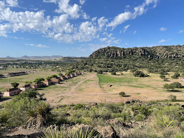 |
| View of Officer's Row from the Scenic Overlook on the North Ridge |
CHAMIZAL NATIONAL MEMORIAL
Some NPS sites are cool because they exist for historical reasons, and are important ways to remember parts of history that would otherwise be forgotten. I had no idea that Chamizal National Memorial even existed, and never knew about the controversy between the US and Mexico over the boundary dispute that led to its existence. So it was nice to be able to spend some time and learn a little about our history.
The park basically commemorates the 1963 Chamizal Treaty that peacefully resolved the 100-year old border dispute between the US and Mexico caused by the shifting Rio Grande River. In 1848, the Treaty of Guadalupe Hildago defined the border as the deepest part of the Rio Grande, but a huge flood in 1864 (and subsequent floods) shifted the river into a horseshoe bend, causing around 600 acres to move into US territory. The land - called Chamizal - was settled and incorporated into El Paso, but both the US and Mexico claimed it as their territory. To prevent further flooding, channels were dug at the base of the horseshoe, but since man-made alterations didn't change the border, an 'island' of Mexico called Cordova Island was created that jutted into the US.
After decades of negotiations, the two countries settled their dispute by signing the Chamizal Treaty. Mexico and the United States shared the cost of a man-made channel to prevent the Rio Grande from shifting in the future.
The memorial is now an urban park and cultural center (although most activities and performances have been suspended because of COVID). I got there about 40 minutes before the visitor center opened, so I had time to meander around almost the entire park. It's interesting to walk along the outer loop at the edge of the park, since you walk right by the border and the crossing station. There is also a robust Jr Ranger book and a nice museum, plus the rangers are really friendly and chock full of information!
This isn't an area of the country that I'd normally find myself, so I'm glad I had an excuse to visit. As always, the parks were totally fascinating, each with a very distinct feel and all with interesting information. If you ever find yourself in the neighborhood, I highly recommend taking the time to visit them all!


