My second teacher PD of the summer was again a space related workshop - "The Space Race on the Space Coast" - held at the Kennedy Space Center in Cape Canaveral, Florida. Now to be honest, I wasn't exactly thrilled to be visiting Florida, but I WAS excited to learn about the history of NASA and I was eager to visit the National Parks that happened to be located in Florida. So I connected with a teacher friend and planned a few extra days around our workshop to see the sights. I had met Joann the year before at another teacher seminar, and was glad that she was also eager to see some National Parks.
CASTILLO DE SAN MARCOS NATIONAL MONUMENT
Founded by the Spaniards in 1565, St. Augustine, Florida is the oldest continuously inhabited European settlement in the US. After earlier wooden forts were destroyed by English raids, construction on the coquina stone fort began in 1672. Coquina is a sedimentary rock made up of shells and limestone. It made for an excellent building material, since cannonballs that hit the fort did very little damage. Instead of shattering the walls, coquina stone compressed and absorbed the shock of the hit.
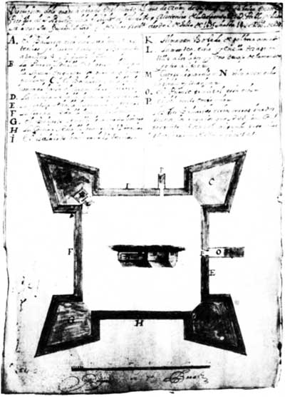 |
| Construction plans, 1677 |
The fort has a cool design, with diamond-shaped bastions on each of the four corners creating a star-like shape. Since nobody had made a structure with coquina before so they didn't know how strong the walls would be, the Spaniards made extra thick walls - up to 19 feet thick on the ocean side!! Surrounding the fort was a dry moat that could be flooded with seawater in case of land attack. So even though Castillo de San Marcos was attacked several times, it was never taken by force.
The Castillo sits right in downtown St. Augustine, at the mouth of the Matanzas River. We toured the inside of the fort and even got to see a cannon-fire demonstration!
 |
| Spoiler alert: It was disgusting. And sadly, I am no younger. |
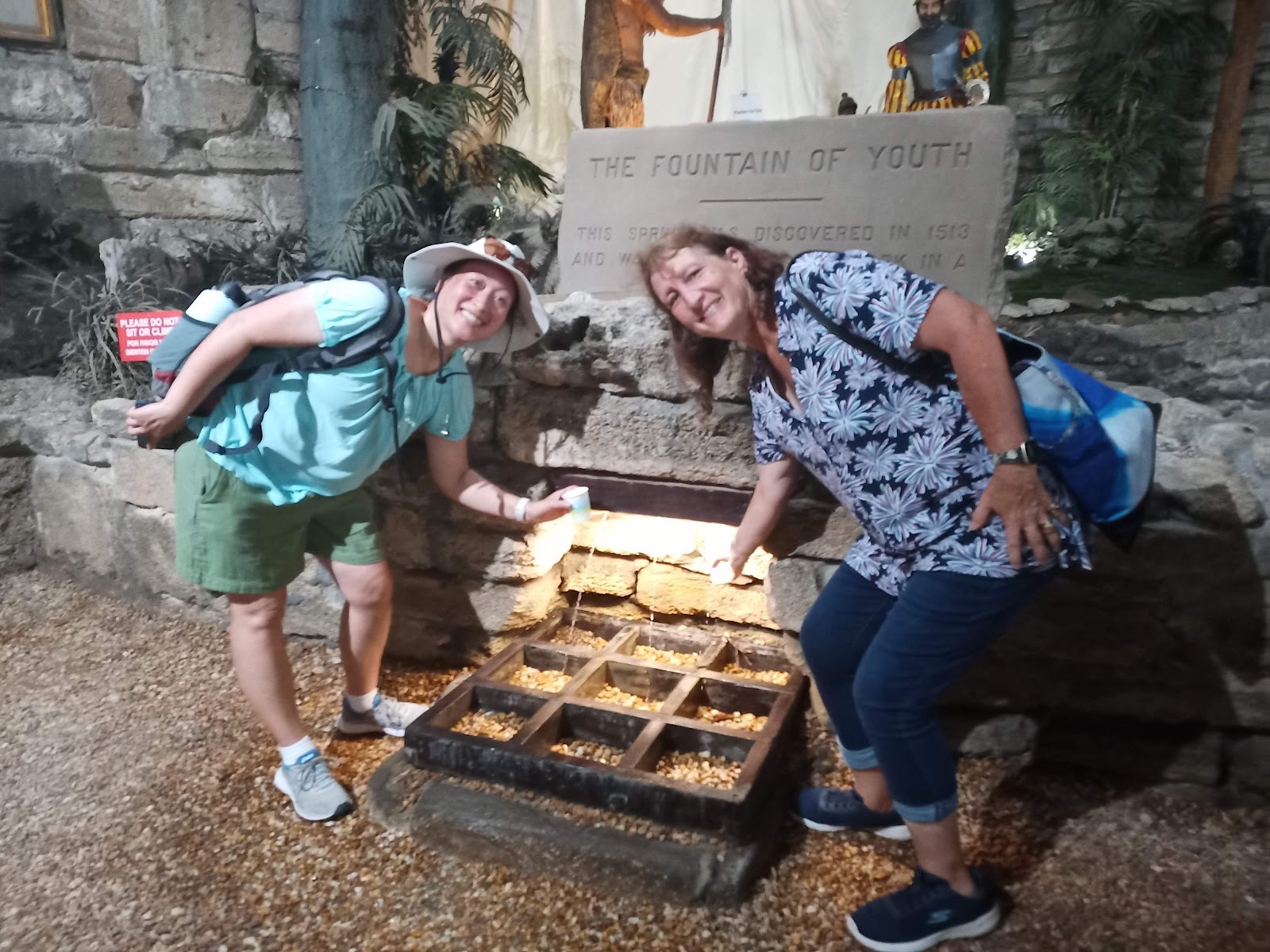
Afterwards, we made a quick stop at the Fountain of Youth Archaeological Park, where Ponce de Leon supposedly landed in 1513 while looking for the Fountain of Youth.
Yes, we tasted the water. Blechhhhh.🤮
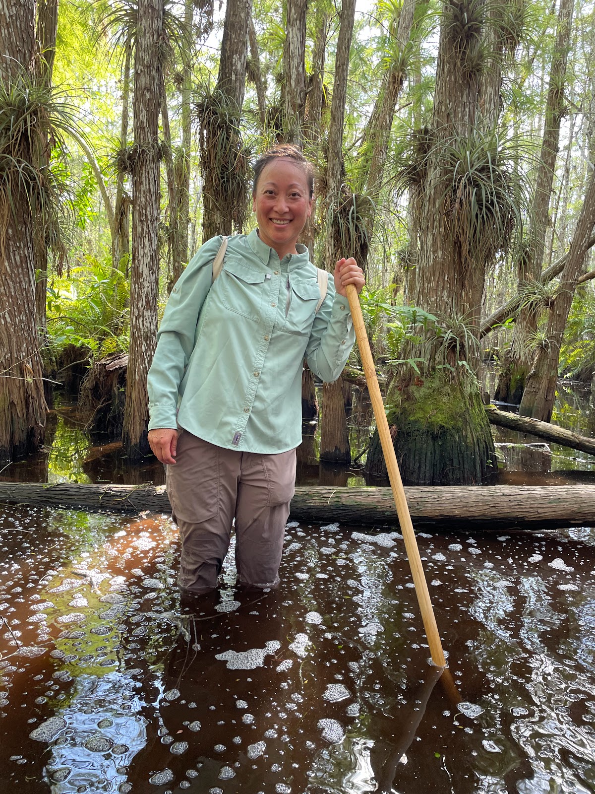
TIMUCUAN ECOLOGICAL & HISTORIC PRESERVE
Before the Europeans reached the new world, the native Timucua people lived in Northern Florida. Sadly, they were completely wiped out by the 1700s. This preserve protects not just the stories of the Timucuan, but the wetlands and marshes of northeastern Florida, the history of slaves at the Kingsley Plantation, and the French colony of Fort Caroline.
 |
| The maze of waterways of the salt marsh. |
 |
| The row of slave houses at Kingsley Plantation |
The Kingsley Plantation, which sits on the north end of Fort George Island, grew cotton, sugar, and corn. Zephaniah Kingsley and his wife, a former slave that he bought from Senegal, lived there for about 25 years. The plantation is now known for the well-preserved tabby slave houses - constructed with the durable cement tabby made from burnt oyster shells, sand, and ash.
 |
| A great audio tour explained the sights around Fort George Island |
Did you know that gopher tortoises dig long burrows that are home to more than 350 other species? They are one of the keystone species in the area, and it was so exciting to find one in its burrow!
 |
| Hello, gopher tortoise! I see you! |
Within the preserve is also Fort Caroline National Memorial.
Around the same time that the Spaniards were establishing themselves at St. Augustine, the French also sent small parties to settle in the New World and stake their claim on the riches they hoped to find. In 1562, Jean Ribault set off from France for the first expedition, erecting a monument near the mouth of the St. Johns River in 1564. Rene de Laudonniere (who had accompanied Ribault) established the first permanent settlement - La Caroline.
The 250+ colonists included artisans and women, many of whom were Huguenots (French Protestants) looking for religious freedom. They struggled in their first year, relying heavily on the Native Americans in the area. When Ribault returned from France in August 1565 to bring reinforcements, the Spanish decided to oust the French and maintain their stronghold in Florida. Ribault fled in his ships, but was thwarted by a violent storm. Meanwhile, another Spanish garrison traveled over land and attacked La Caroline. A few dozen people escaped, and of the remaining 200 only around 50 women and children were spared. Ribault surrendered to the Spanish but the colonists were executed as heretics. The location of the massacre is now called Matanzas - Spanish for 'slaughters.'
Even though the exact location of Fort Caroline is unknown, the replica - a small triangular fort - shows the small size of the ill-fated colony and gives a taste as to how the French had to defend themselves.
FORT MATANZAS NATIONAL MONUMENT
All this turmoil amongst the various factions coming to the New World meant each nation needed a way to protect its settlements. The Spanish, to help protect St. Augustine, knew they needed to keep tabs on the Matanzas Inlet, so a few years after the massacre, they began manning a wooden watchtower. The current coquina tower was completed in 1742 on tiny Rattlesnake Island in the middle of the inlet.

A quick 5-minute boat ride took us to the Island, where we were allowed to wander through the tiny fort. I could easily imagine how the lazy days would be if I were one of the soldiers stationed sent for my 30-day stint... I'm sure there was a lot of fishing and swimming and card games... and not much else going on!
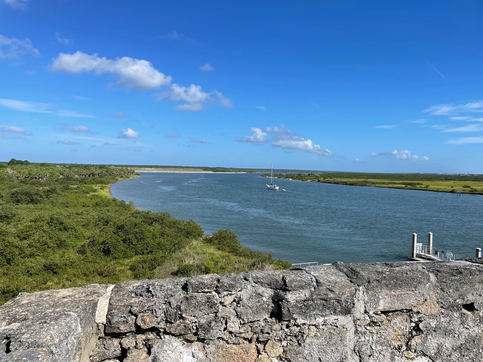 |
| The view up Matanza Inlet towards St. Augustine |
CANAVERAL NATIONAL SEASHORE
Before heading back to Orlando to meet up with the other teachers for the NEH seminar, Joann and I stopped off at the Canaveral National Seashore. It's an interesting place since much of it has no roads - and while it is the longest stretch of undeveloped land in Eastern Florida, the Kennedy Space Center and many of the launch pads are within the park boundaries. The road going down from New Smyrna (the northern end) stops at Apollo Beach - and while the timing wasn't right for us, I can only imagine how cool it would be to watch a rocket launch from the beach!!
Before Ponce de Leon and other Europeans came to Florida in the 1500s, the Timucuan people lived up and down the Florida coast, including at sites around Canaveral. We hiked around Turtle Mound, a shell midden from over 2000 years ago. We also saw a few gopher tortoises, which hopefully means they are rebounding from their threatened status!
 |
| Many of them had scars ☹️ |
One of the more interesting sights was later in the week, when we visited the southern end of the park and got to view a large number of manatees. Manatees, or sea cows, are herbivores that feed on aquatic grasses in shallow coastal warm waters. Because they have no natural predators, they are docile and slow-moving - which means they are particularly susceptible to boat collisions. It was sad to see the scars on the backs of many of the manatees that we saw.
 |
While manatees are often solitary, they do congregate during breeding season and in pockets of warmer waters.
We saw over 50 individuals from our viewing deck! |
KENNEDY SPACE CENTER
 |
With Launch Director Mike Leinbach -
the man who decides "Go" or "No Go!" |
During the next week, we stayed on Merritt Island and attended the NEH seminar "Space Age on the Space Coast". We attended lectures from historians, scholars, former astronauts, and even the Space Shuttle launch director! Each day we had some time to wander around the Kennedy Space Center, and OMG it was SO COOL. It's like Disneyland for nerds, and I would highly recommend it (I'd even choose it over going to Disney if I ever find myself in Florida again!)
Did you know? The main reason why the Kennedy Space Center is built on Cape Canaveral is due to its location: Because of the rotation of the earth, rockets are always launched to the East - because the velocity of the earth's rotation is added to the speed of the rocket, giving it an extra push! And the velocity of the earth is faster near the equator than it is at the poles. And having a launch pad on the East coast means that in the event of an accident, debris will fall into the ocean instead of onto someone's house... so the most eastern/southern spot is Florida!
 |
| Saw my first horseshoe crab! |
The week wasn't just about space. We visited the Harry T Moore home, where civil rights activists Harry and Harriet Moore were assassinated when a bomb was placed under their house on Christmas in 1951. We also learned about the environmental impacts made by the space center, and also went kayaking to see bioluminescent plankton - when the sun went down, you could see the trails behind the kayaks and the oars as the plankton would fluoresce after being disturbed - very magical!
 |
The VAB: The doors on the sides are 456 feet high,
so rockets are assembled vertically and rolled out! |
But the coolest thing we did was see the launch complex. We first drove by the Vehicle Assembly Building, the VAB, where each rocket or shuttle is housed ahead of time. While we were there the Orion rocket for the Artemis mission was there, and if we looked reaaaaaally closely through the giant doors, you could just see the ghostly shape of the SLS rocket!
 |
| Launch Pad 39B: Ready for Artemis! |
On our way to the Apollo/Saturn V Center, we took a detour to see several of the launch pads, including ones used by Blue Origin and SpaceX, as well as Launch Pad 39B where Artemis 1 would be launching from. At the Center, not only can you touch a moon rock but there is a great simulation of being in the control center during the moon landing. I loved it!!
 |
| The control center at LC-26 is now a museum |
Because the US Space Force is now officially a branch of the US military (no, it isn't just a comedy TV show!), a large swath of Cape Canaveral is now closed to the public. In fact, they said we were one of last civilian tours that was going to be allowed on base, so we definitely appreciated being there and seeing such historic sites! There are SO many historical sites on what is now the Space Force Station, and I'm not sure the public will be allowed in the future.
The first US satellite was launched from LC-26A in 1958, and it was so cool seeing the computers used over 60 years ago to get an object up into space:
 |
A stamp on the side of the complex reads "Abandon
in place," which means to abandon it without maintenance. |
By far the most moving (and most somber) of the sites we visited was Launch Complex 34. In 1967, as the US was preparing the Apollo missions to the moon, the Apollo I fire broke out and killed astronauts Grissom, White, and Chaffee.
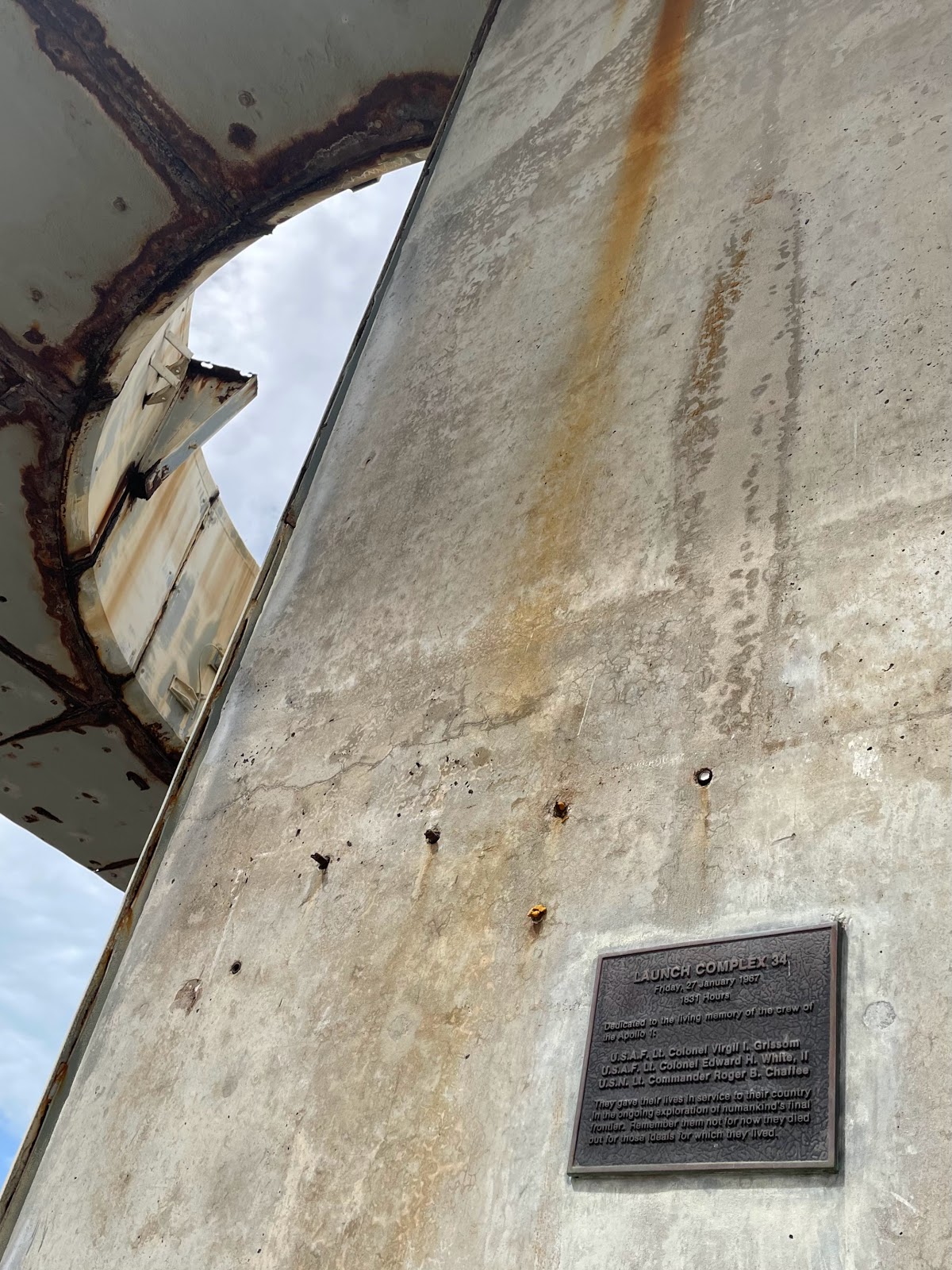 |
| One of the memorial plaques |
The complex was decommissioned after the launch of Apollo 7, the first crewed mission, in 1968.
I'm grateful we got to spend some time at the LC 34 Memorial, because it is a good reminder that there are often setbacks along the road to progress. The vast majority of the week was awe-inspiring, impressive, and uplifting - and I definitely got shivers while touring the Kennedy Space Center exhibits.
 |
| The Atlantis shuttle exhibit was out of this world! |
 |
With my new teacher friends Joann,
Pam, and Rebecca! |
They did a fantastic job telling the NASA story and explaining why it matters, and I look forward to seeing what future exploration brings!