Saturday, July 31, 2021

Ecuador, part I: Guayaquil

In an unexpected surprise trip, I'm traveling to the Galápagos this summer - thanks Lindblad Expeditions!! And as part of their generosity, I was allowed to invite a teacher friend to join me, so I chose my UCSF hospital school counterpart, Erika - who used to volunteer at LPCH. We decided to come a couple days early to Ecuador, because 1) a friend who went to the Galápagos a couple years ago had their flight delayed and missed the first few days of the cruise; 2) we didn't want to feel tired when we started the expedition, and 3) ECUADOR! Why not?!

I actually didn't find out about this trip until I was in Boulder City, about a month ago. After many phone calls trying to figure out the best packing methods and things to bring, Erika and I finally flew from SFO through Miami to Guayaquil. The largest city in Ecuador, Guayaquil is the jumping off point for any tourist going to the Galápagos. The original settlement was located on Cerro Santa Ana, a hill along the Guayas River that allowed for great visibility and defense. It was founded in 1538 by Spanish conquerors, and went through a period of sieges and pirate attacks.

For many years, Guayaquil was decaying - with abandoned buildings, degradation of the city center, and dangerous neighborhoods. But in the 1990's it went through a period of renewal and transformation - particularly through the restoration of Malecón 2000, the riverside boardwalk. One thing we noticed while walking around was the police presence - they seemed to be everywhere, which was both reassuring and, in a way, slightly unsettling.

The colonial architecture of Las Peñas
Overall, we were absolutely stunned by this lovely city! We arrived at our hotel just north of Cerro Santa Ana and the Malecón in the early afternoon, then headed out for a stroll. We started first in the charming Las Peñas neighborhood, filled with colorful houses and cobblestone streets. After winding our way around the twisty streets at the base of Cerro Santa Ana, we found our way to the Malecón. There are lots of fountains, gardens, statues, and monuments all along the boardwalk, making for a really nice place to hang out. We found a late lunch at the food court area, then headed back north. 

The start of the 444 steps

Since it lies between the Malecón and our hotel, Cerro Santa Ana was our next stop. Several years ago, this was a seedy, dangerous neighborhood but during the period of revitalization, the area was cleaned up and is now a nice tourist destination. We climbed the famed 444 steps (they're numbered!) on Diega Noboa y Arteta, the main artery up the hill. 

With Juan Pueblo,
the mascot of Guayaquil

Along the way there are several bars and restaurants, little plazas and statues, as well as cannons and the remains of the old fortress. At the top of the hill is the Plaza de Honores and the faro, a blue and white striped lighthouse that is a replica of one on Isla Santa Clara guarding the entrance of the gulf. From the very top of the lighthouse, we had a gorgeous 360° vista of the entire city, including the Capilla de Santa Ana, the chapel on the top of the hill originally built in 1548(!). 


The view of Plaza de Honores and Capilla de Santa Ana 

The view from the gondola
The next morning, we took the Aerovia across the River Guayas to Durán. It was a fun view of the entire Malecón, and interesting to see everywhere we walked yesterday. The Aerovia is brand new gondola, only opening in December of 2020, and there weren't many people riding it. It was meant to be a faster alternative for commuters going from Guayaquil to Durán - a 45 minute bus journey - and our trip across was less than 10 minutes long and cost $0.70 each way.

Unfortunately, the Durán bridge to Santay Island was temporarily closed when we arrived (a few years ago it had been hit by a boat and is still not open), so we rode back across to Guayaquil and walked the 4 km down the Malecón to the Guayaquil-Santay Bridge. 

Biking across the Guayas River
The boardwalks, with Orange Trumpet flowers
The drawbridge was up when we got there, so we walked around the neighborhood while we waited for it to reopen. This was not a touristy area of town, but it was interesting to see a different part of the city. Not long after, the bridge reopened and we rented our bicycles and made our way across. There was only one other couple that had crossed the bridge right before we did, so we pretty much had the entire island to ourselves. Santay Island is a protected reserve in the middle of the Guayas River; surrounded by mangrove forests, it has an ecovillage of about 50 homes, as well as a crocodile farm and amazing birdwatching. The boardwalk winds through the marsh, where we saw tons of butterflies (including huge blue morphos) and lots of birds. We also saw a Giant Sensitive Plant - the leaves close up when you touch them! At the crocodile farm there were also tons of birds - white ibis, yellow and black crowned night herons, and parakeets. There were also a few green iguanas in the enclosure with the crocodiles.

We had a delicious lunch of chicken and rice in the little village, before biking back to Guayaquil. 

The Ecovillage on Isla Santay

This gorgeous orange guy kept coming for me...
It was a quicker walk back to the Malecón, and on our way back to the hotel, we stopped at Parque Seminario - a square in the middle of the city central that is curiously filled with wild iguanas. They are all along the paths and grassy areas, as well as being hidden in the bushes and in the trees. It's so strange walking through the bustling city streets, only to stumble into this park! While it was so cool to see them all, it bugged me that people were feeding and petting them. But I guess that's why they all congregate there, and don't wander off into the city streets.

Iguanas were everywhere underfoot, but don't forget to look up -
they sometimes fall from the trees!

After a bit of a rest (and a delicious fruit smoothie), we walked back up Cerro Santa Ana for dinner. My chuleto y arroz and a bottle of water cost a total of $4, including tax! 

The next day, we had a lazy morning before transferring to our trip hotel, the Hotel del Parque. It's a beautiful old hotel on the grounds of the Parque Historico, a historic area with a small zoo, gardens, and traditional crafts and shows. Because of COVID most of the park was closed, but it was still nice to wander around the grounds and see the monkeys and iguanas. The funny thing is that when we checked in, they wanted to give us two rooms, both with king sized beds, and we told them we didn't need two rooms - we could just share. The lady was like, "huh???" but gave us what we wanted. Our room is HUGE and right outside is a gorgeous orchid patio where we sat and read for a while. 
Not a shabby place to spend an afternoon...
A lovely start to our expedition!        

Monday, July 19, 2021

Sun, Sand, and just a little bit of Snow

Well, the COVID pandemic derailed several trips these past two years, and for the second summer in a row, I wasn't able to go on my narwhal expedition. But never fear! I'm still learning about the environment and doing some traveling this summer!

alt text
See the "bathtub ring" in Lake Mead?
Highlights the water level that is at an all-time low
Instead of going to the Arctic, I spent a few weeks studying in Boulder City, Nevada, in >110° degree weather - it was one of the hottest experiences of my life, but really drove home what climate change is doing to our planet. We studied at Hoover Dam (feeling first-hand the conditions that Depression Era workers were facing as they were building the Dam in the early 1930's) and seeing the historically low water levels in Lake Mead. Did you know that 7 states get their water from Lake Mead, and that Los Angeles and the Imperial Valley (where a LOT of our food is grown) depends on this water source? Not to mention the power generated by the dam, which is now threatened because there isn't enough water in the lake? It is really sobering to think about.    Originally named the Boulder Dam, the 726 foot tall, 1244 ft wide, 660 ft thick (at the base) dam was actually completed ahead of schedule.
Buddies with the President, much?
Oh, not that one? This other one? 
During my time in Boulder City, I also had the opportunity to visit Las Vegas and its vicinity. We were invited to the home of Sara Denton, mom of journalist Sally Denton (one of our speakers). The Denton family is one of Nevada's liberal political voices - LOOK WHAT WAS ON HER WALL! Why yes, that's her with Johnson, Clinton, Obama, AND Biden. And below that was a handwritten letter from Truman.

Whatchoo lookin' at, kid?
Sign, schmign.
Along with lectures, we had time to explore the city. We hiked along the old railroad tracks that once carried workers and materials from Boulder City to the dam worksite. The trail goes through several tunnels (with bats!), and we even saw some bighorn sheep! 
On another free evening, my new friends and I went into Las Vegas to walk around the casinos and see the sights. I'll be honest - it was weird seeing so many unmasked people, but it was fun seeing the Strip with the new eyes of people who've never been before! 
With my new pals Jessica, Travis, Catherine, Derek, and Jeanne

We also spent a morning at Meow Wolf, which wasn't quite up to par with the Santa Fe original, but fun nonetheless. In this version, we explore the strange grocery store OmegaMart - and the giant corporation behind it that has harnessed a mythical energy source.
On another free day, Jessica, Derek, Travis and I hiked Red Rock Canyon - a lovely respite from the heat. Since it is at a slightly higher elevation, it was only about 85°... downright chilly after a week in 115° weather!
The view from High Point Overlook
Catching tadpoles! Photo by Jessica Fauteck

On the hottest day of the trip, (yes, unfortunate planning), we traveled to the Valley of Fire for a day hiking through the park. Despite the heat, it was a stunning place with cool rock formations and petroglyphs. 
Valley of Fire - photos by Jeanne Scheppach
After my two weeks in Boulder City, I decided to take the long route back home, camping and visiting several natural wonders with my cousin Evelyn. 

First stop was Cathedral Gorge, one of Nevada's state parks. This place is a true hidden gem, with some of the most remarkable geologic features that I've ever seen. A million years ago, the area was covered by a freshwater lake, which deposited a layer of silt. Over the years, rain and melting snow carved gullies and fissures into the siltstone, creating thin canyons known as caves. Unlike the slot canyons found in other areas of the Colorado Plateau, these aren't caused by flash floods, so many were so thin that we had to shimmy through sideways and ended in dead ends. 
The 'caves' of Cathedral Gorge State Park.
Next was Great Basin NP, one of the least-visited units of all the National Parks. I'd always wanted go, but thought of it as basically being in the middle of nowhere (it's on the far east side of Nevada, bordering Utah - but it's only 4 1/2 hrs from Las Vegas and less than 4 from Salt Lake City - totally worth the drive). 

One of the most famous things about Great Basin is its night sky - because of its high elevation and low light pollution, it is supposed to be amazing for stargazing. Unfortunately, the week we were there, the Bootleg Fire in eastern Oregon combined with other wildfires on the West Coast blew so much smoke that the haze blocked out much of our night sky. Another victim of climate change :( Hot weather also meant no campfires... did you know you can cook smores on a frying pan? 
Instead, we spent several days hiking around the park. Did you know there are glaciers in Nevada?? You can easily hike to one via the Glacier Trail, at an elevation of around 11,000 ft! They estimate the size to be about 2 acres, and will probably be gone in 20 years. 
Wheeler Peak Glacier
Me, with my new 3,500 year old pal! 
Did you know? The oldest living thing ever found on earth was a Great Basin bristlecone pine, found in the Wheeler Grove in Great Basin National Park - until it was accidentally cut down by a grad student in 1964. Called the Prometheus Tree, it was estimated to be between 4,800 - 5,000 years old!  There's something sublime about hiking through a bristlecone forest, knowing everything around you is resilient and august. The hard, resinous wood is resistant to decay, so even the dead trees stay standing for thousands of years. Bristlecones grow in the harshest of environments - high elevations in bad soil and rough weather, such as the rocky dolomite soil found in the mountains surrounding the Great Basin. 
At the end of the trip, we also hiked through the Methuselah Grove in the White Mountains of the Eastern Sierras, where the current oldest tree, Methuselah, is found (but the exact location is kept a secret since you know there are awful people that would damage or destroy it!) Climate change is also threatening the bristlecones - warming temperatures are allowing other species to move into their territory, competing for the already scant resources. 
The Methuselah Grove, in the White Mountains.
A secret wonder of Great Basin is the vast limestone cave system that lies below the park, and you can tour a portion called Lehman Caves. It has some of the most incredible formations I've ever seen in a cave, including over 300 rare shield formations! Cave shields are thought to be formed when calcium-rich water is squeezed through a joint or crack, building up plates of calcite precipitate parallel to the cracked wall. As more calcite is deposited, the plate grows larger in concentric rings, then water drips down to form the draperies. 
The speleothems of Lehman Caves
To get home, we drove across Nevada along Hwy 50 - known as the 'loneliest road in America.' Nevada's tourism board really did a great job marketing this road, and it was decidedly NOT lonely. Several historical towns such as Ely, Eureka, Austin, and Fallon are found along the route, making it an interesting and enjoyable drive. 

Middlegate, a former stagecoach stop and Pony Express station
Stokes Castle, outside Austin
Hwy 50 partly follows the former route of the Pony Express - the horse-mounted mail service that ran for 18 months during 1860-61. 
Sand Springs Pony Express Station - in the background you can see
the large sand dune that curiously appears in the middle of the Great Basin
There were around 186 Pony Express stations at 10 mile intervals from Missouri to California, and you can still see the ruins of some along the way. Sand Springs Station was buried under shifting sands after it was abandoned, but was rediscovered and excavated by archaeologists in 1977.
Back in California, we hiked Lundy Canyon through one of the most amazing wildflower blooms that I've ever seen. In one field of tall Sierra Larkspur, the hummingbirds were so numerous you could hear them chirping and buzzing all around! 
The wildflowers of Lundy Canyon

The COVID pandemic has caused many people to go outside, and while I've heard that the National Parks are overcrowded, Great Basin is so remote that we didn't really see the throngs of people that other parks might face. But when we got to Devil's Postpile National Monument, we found the crowds. 
Rainbow Falls
To get to the actual site, a mandatory shuttle bus is set up at Mammoth Ski Resort, and the lines were LONG. We waited over an hour and a half to get to the trailhead!  But most people went straight to swim at Rainbow Falls, missing what I consider to be one of the most interesting aspects of Devil's Postpile. 

The postpile is an interesting geologic feature created when a 400-foot deep pool of molten lava formed parallel cracks to relieve pressure as it cooled. Later, a glacier moved over it, carving and polishing the top. You can easily see the hexagonal formations formed by the cooling lava, and the glacial striations marking the direction where the formation was rubbed. This can clearly be seen from the top of the postpile, so I found it odd that when we got to the top, we were the only ones there. Given how many people were crowding onto the bus to get into the park, you'd think there'd be a huge throng trying to see this natural wonder. After talking to the park ranger, we found out that most people don't bother hiking to the top, even though it isn't a very long detour. While I'm glad more people are trying to get out to enjoy nature, I do think some people actually need to be taught how to appreciate nature...
Devil's Postpile from the base and the top

Overall, it was an amazing trip and it was so good to be back outside! Thanks, Ev, for joining me!

Tuesday, December 31, 2019

Winter in Wonderland: Yellowstone


Every year, over four MILLION visitors travel to Yellowstone, the world's first National Park. It's no wonder - the park is a beautiful landscape of mountains, meadows, lakes, geothermal features, and abundant wildlife. But the downside is that all those people mean lots of traffic and pollution, parking problems and blocked views.


It was c-c-c-cold!!!
But in the winter, Yellowstone gets fewer visitors per MONTH than it does during a busy summer day. The figure-8 road that runs through the park is closed to the public, and only snow coaches and snowmobiles can make it to the heart of the park. The landscape is covered in a thick layer of powdery snow, so cold and dry that individual flakes stay separate. Trees are coated with snow and rimefrost, the frozen ice from the condensation spewed out by the nearby geysers and fumaroles. It's sublime.

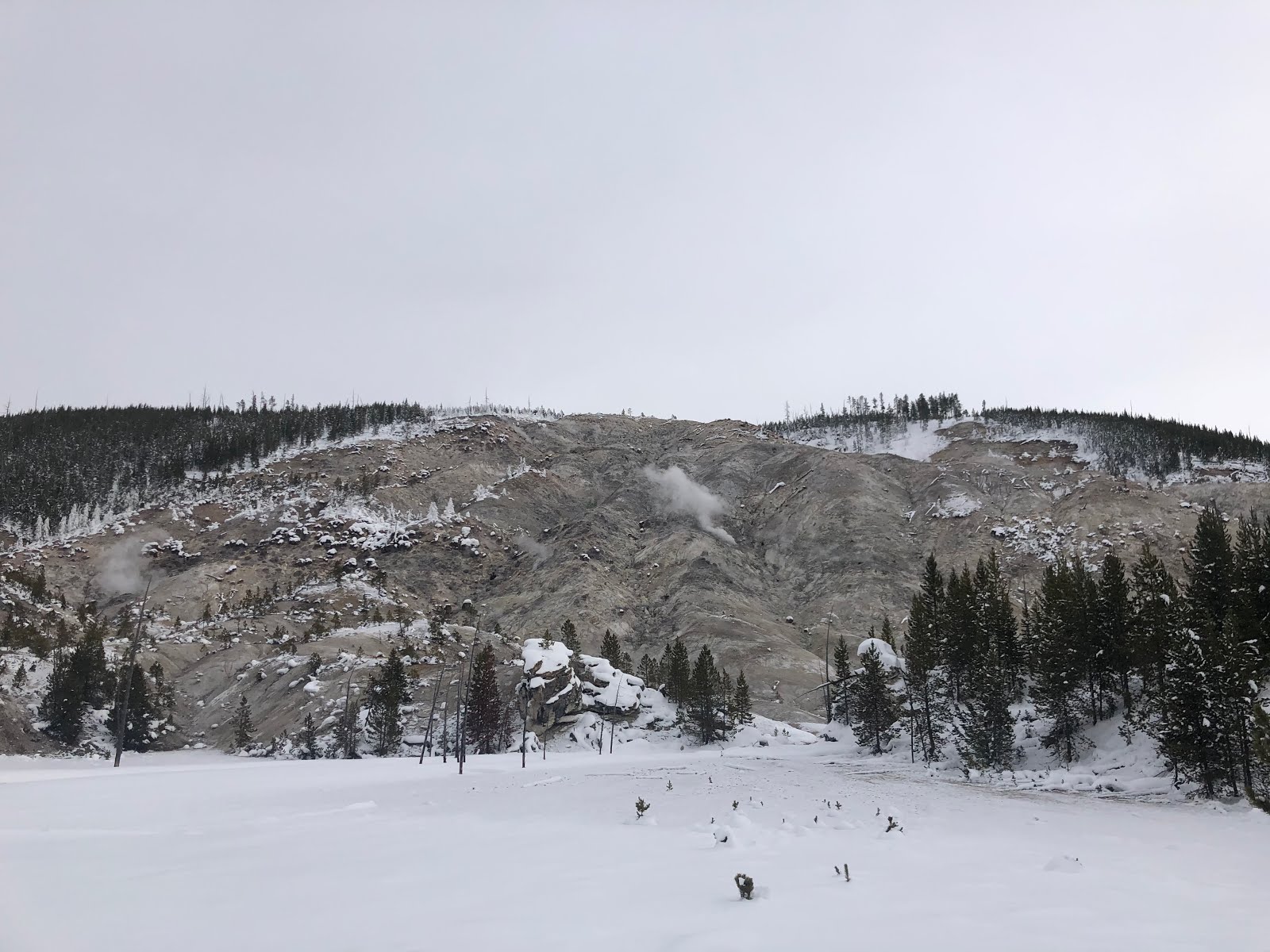
Rimefrost near Steamboat Geyser


Ever the willing adventure partner, Anil flew out to come with me. We stocked up on gear (plenty of long underwear, thick socks, and handwarmers!) and headed out to Bozeman, Montana on the first day of Winter Break.

Flights always seem to get in late (after midnight) to Bozeman, so we found a nearby hotel and took the shuttle bus into the park the next day. Bozeman was cold, but at 2,000 ft higher elevation, the entrance to Yellowstone was much colder. Thank god for snow gear!!
The Yellowstone area has been used by humans for at least 11,000 years. The first white explorers, members of the Lewis and Clark Expedition, came in 1805 and observed at least one geothermal area - a place described as "fire and brimstone" that most people thought were a myth. It wasn't until 1871 when the Hayden expedition, including photographer William Henry Jackson and painter Thomas Moran, reported to Congress and convinced the government to set aside the land under federal protection. In 1872, President Ulysses S. Grant signed The Act of Dedication, creating Yellowstone National Park. The vast majority lies in the state of Wyoming, but three percent is in Montana and one percent is in Idaho.

The main reason why Yellowstone is such a remarkable geologic area is because of the supervolcano lying underneath. The Yellowstone Caldera is the largest volcanic system in North America, around 40 miles long and 20 miles wide.
Three major eruptions have occurred - the most recent being 640,000 years ago, which produced 240 cubic miles of pyroclastic material (over 1,000 times greater than Mount St. Helens). The others were 1.3 million years ago, and 2.1 million years ago (the most violent at 588 cubic miles of material). Ash from that first explosion went as far South as Mexico and as far east as Illinois. Each explosion probably led to the extinction of many species and caused significant changes in weather patterns.

With over 10,000 hydrothermal features, Yellowstone is the most active spot on earth. The current geothermal activity is because of the magma chamber lying close to the earth's surface under the Yellowstone Caldera. Molten lava heats up the underground aquifer, and depending on the underground plumbing system and makeup of rock, one of four geothermal features can be present.
 Image result for yellowstone geothermal features diagram

Fumaroles at Roaring Mountain

Cistern Spring, Norris Geyser Basin
All hydrothermal features need water, heat, pressure, and a plumbing system. The difference between geysers, hot springs, mud pots, and fumaroles depends on the amount of available water, the makeup of the surrounding soil, and the plumbing system.

Mud Volcano
Vixen Geyser, Norris Geyser Basin


We did get to see all four features - mostly at Norris Geyser Basin, but we also visited West Thumb, Hayden Valley, Lamar Valley, and we stayed for four nights at the Upper Geyser Basin (and Old Faithful).


We started the trip at Mammoth Hot Springs, with three days exploring the northern part of the park. It was especially interesting to see the travertine terraces, whose hot water keep it from being covered in snow. Different bacterial thermophiles live in the springs, turning the waters different colors based on the temperature and type of bacteria. Hotter waters generally grow deep blues and greens, while cooler temperatures foster oranges and yellows. The terraces are formed when thermal waters dissolve calcium carbonate in the limestone bedrock as it travels to the surface. When it reaches the surface, carbon dioxide is released from the water, causing a precipitation of the calcium carbonate.

 With most of the park closed to public vehicles, dozens of snowmobile tour groups come in from West Yellowstone just for the day. Looks fun, but we saw two different accidents (and the people looked SO cold!)


One of the highlights of the trip was the early morning 'Wake Up to Wildlife' tour, leaving before the sun rose. We went into the Lamar Valley to see the many animals that migrate there in the winter in order to forage in the open meadows.


Bison (also called buffalo), are an icon of Yellowstone. Over 5,000 bison roam through the greater Yellowstone ecosystem, but that number grew from only around 23 individuals in the 1800s because of poaching. Historically, bison roamed the American West in huge numbers - between 25 and 60 million - until they were hunted to near extinction. In the mid to late 1800's, they were down to 23 individuals, until the US Government stepped in by introducing a captive herd. Now, over 5,000 bison roam through the greater Yellowstone ecosystem.


Can you spot the wolves?
The story of the Yellowstone wolves is just as interesting - they were purposely exterminated in the 1920's, back when the park believed that any carnivore was a 'bad' animal. When the elk population exploded, there was worry of plant die-off and land erosion. They then realized wolves were part of a healthy ecosystem, and in 1995, 41 wolves were reintroduced to the park. Today, around 100+ wolves help keep Yellowstone healthy. We were lucky enough to see two black wolves on our first full day in the park, bounding through the snow at Swan Lake Flats.

Often mistaken for wolves, coyotes are much more abundant in the park. With the white snow covering the landscape, it was easy to spot these canines hunting for mice under the snow.
Head-first diving into the snow!


A highlight was seeing moose, which aren't very common in the park (the fire of 1988 burned much of the moose habitat, and they are just slowly returning).

Did you know? Antlers - like on this elk - aren't permanent.
Animals like elk, moose, and deer grow new antlers every year.
Bighorn Sheep


One of the more interesting animals that we got to see was a river otter! Much easier to spot in the winter, playing in the snow.


We also saw many, many different birds - surprising, since it was SO DANG COLD! Did you know that a chickadee goes into forced hypothermia every night, shivering to keep warm? The trumpeter swan is North America's largest waterfowl, with a wingspan of 8 feet! Bald eagles, who normally feed on fish, eat a lot more waterfowl in the winter when their water sources ice over. And the unobtrusive American dipper is the only North American songbird that can swim underwater!
This bald eagle was feeding on fish.
Trumpeter swan


Staying at the Snow Lodge in the heart of the Upper Geyser Basin meant being able to see Old Faithful erupting at all hours of the day. The first time was during the day when hundreds of day snowmobilers were visiting, but the lodge only has 134 rooms so morning and afternoon/evenings are really quiet. When we went to Old Faithful at around 9PM, only 5 other people were out there and a red fox ran across the geyser base just as it started to erupt!

Staying at Snow Lodge also means getting the opportunity to wander around the Upper Geyser Basin, which gave us a close and intimate look at many of the features. We snowshoed around, which was a lovely way to enjoy the area.


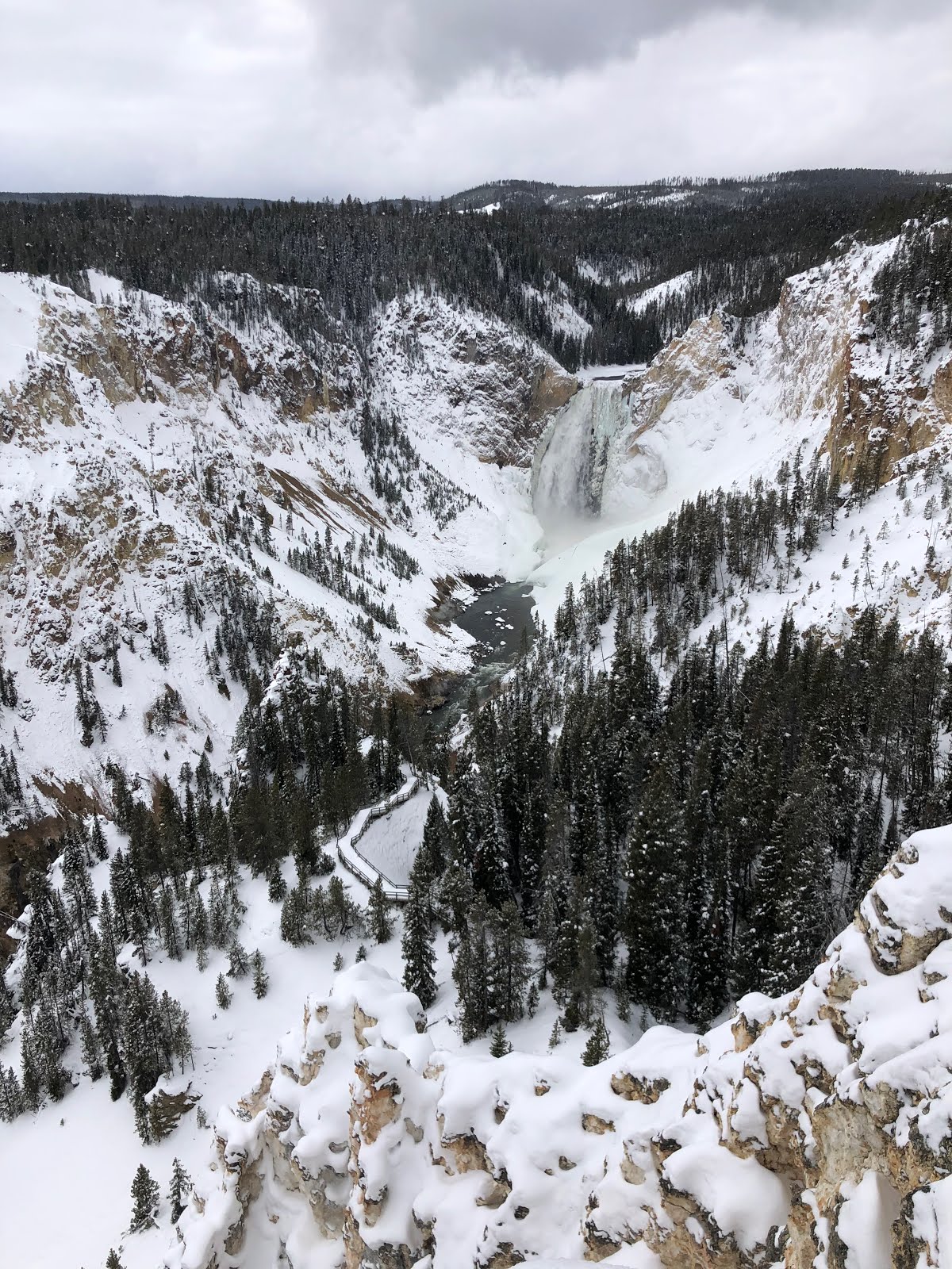
On Christmas Day, we took an all-day excursion to snowshoe around the Grand Canyon of the Yellowstone. We were able to follow a path by the river that doesn't exist in the summer, and it gave us a great vantage of both the canyon and the falls.


Firehole River


Another excursion we tried was the Lone Star cross country ski trip, a 5-mile journey skirting the Firehole River through some of the most beautiful landscape in the park.


We made it to the Lone Star Geyser just in time to see the 45-foot tall geyser erupting. It's a cone geyser, as seen by the mound of built up geyserite, which causes a steady jet to shoot up in the air (as opposed to a fountain geyser).


Another interesting thing in winter is seeing all the animal tracks. After several days of no precipitation, it snowed on Christmas Eve, leaving a clean white blanket that clearly showed new animal tracks. It was fun trying to figure out what animals had left their tracks.
Larger prints are coyote; smaller are mice, squirrel, and/or voles.
Vole on the left, squirrel on the right (see the tail track?)

But the best part of being in Yellowstone in the winter was just admiring the landscape. Amazing!


It isn't an easy trek to get out to Yellowstone in the winter, but if you ever get the chance, its well worth the effort!