Tuesday, July 17, 2018

The Parks and Rec Trek - Week 3

CANYONLANDS NATIONAL PARK, Needles District
Ancient message board?
Canyonlands is an interesting park, because it is divided into three main districts. Since we were already in the general area, we decided to visit the Needles District - not as popular as the Islands in the Sky, but interesting nonetheless.

On our way in, we stopped at Newspaper Rock, an interesting panel with petroglyphs dating back over 2000 years. They don't really know what the figures mean - maybe messages, maybe prayers, or maybe just ancient graffiti. Even so, it was pretty impressive to see.

The Needles, Canyonlands
In Canyonlands, we stopped to see the main overlook into the Needles. This area was created when sandstone began shifting over a layer of salt leftover from an ancient sea. This caused the sandstone to fracture in parallel cracks, which gradually eroded the exposed rock. Over time, it eroded into spires known as the Needles.

You may not see it, but tons of life lives in these dried potholes!
It was also interesting to see the potholes in the sandstone. We hiked around Pothole Point, which was dry now that its summer, but for a few months, fill with rainwater. During this time, lots of different organisms thrive in the tiny pools, some living their entire lifecycles in a few short weeks. They lay eggs, which lie dormant during the dry season, until it because wet enough for them to hatch. Animals such as tadpole shrimp, fairy shrimp, toads, and winged insects all live in the potholes.


NATURAL BRIDGES NATIONAL MONUMENT
Owachomo Bridge
Meandering streams cutting into canyons are what form the bridges at Natural Bridges NM. There are three main bridges that can be viewed in the small park, which you can view from overlooks. These bridges are formed when a slow river makes horseshoes as it meanders in its path. At some point, the river decides to cut a detour, eroding through the thin neck of rock that separates the flow. The stream undercuts the barrier, and seeping moisture weakens the top and helps it to erode - until finally it breaks through and a bridge is formed.

We hiked to the bottom of the canyon to see Owachomo Bridge from a different viewpoint. It was a bit unbelievable to know these bridges are all still eroding, and eventually they'll crumble and collapse, even as new bridges are forming.

The view from Muley Point
On our way to the next stop, we drove through some pretty spectacular Southwestern landscapes. We drove the Moki Dugway to the Valley of the Gods, then stopped for the night in Monument Valley. We stayed in a traditional Navajo hogan, a circular dirt/timber/clay structure that had been built in 1934 by our host's great grandmother. Really cozy, and quite comfortable!

RUN FORREST, RUN!


Monument Valley


The hogan where we spent the night...
Surprisingly spacious and cozy inside!


NAVAJO NATIONAL MONUMENT
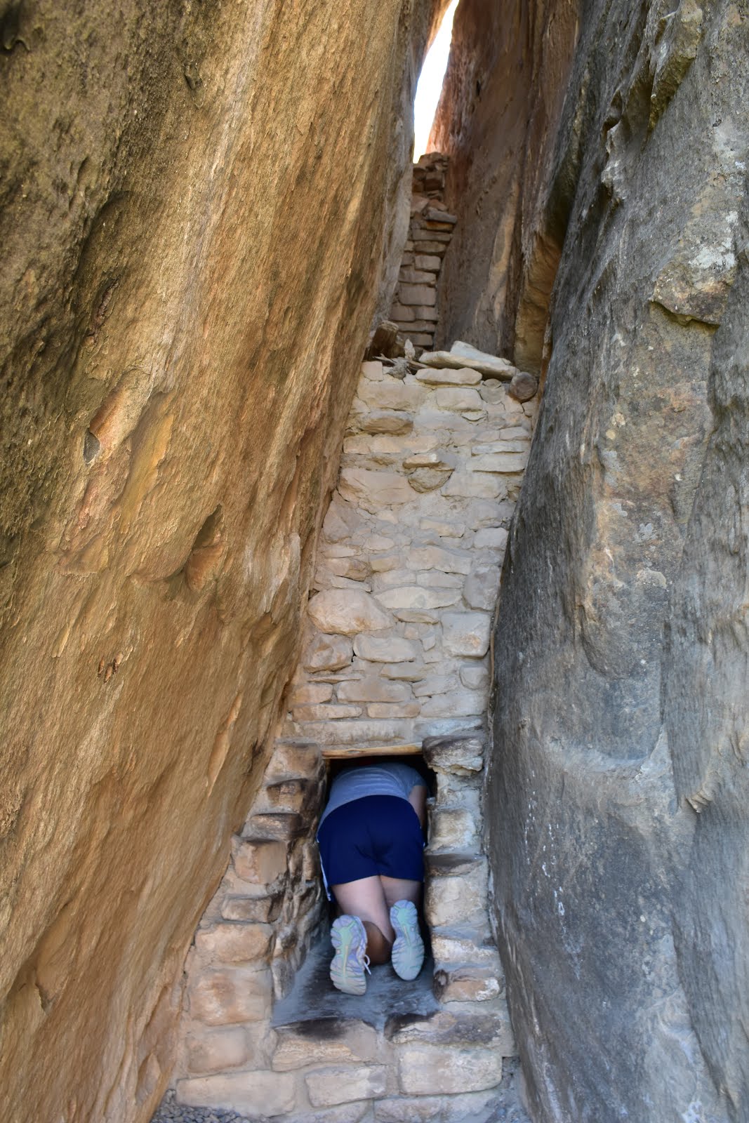
The relic forest on the floor of Tsegi Canyon
This small park is interesting since the two main viewpoints, Betatakin and Keet Seel, are both Ancient Puebloan ruins and not Navajo. The park is named because the Navajo moved in later on, and still occupy the land. But back in the 1200s, the ancestors of the Hopi people came and built in alcoves of Tsegi Canyon. Because the Navajo believed it was bad luck to enter these sites, they stayed basically untouched, and to this day they are some of the best preserved ruins in the area.

We got lucky and made it in time for the guided ranger hike down to the canyon bottom, where we could see Betatakin up close. Normally you can't go down into the canyon, so it was nice having a semi-private tour (there was only one other person). The bottom of the canyon has a lot of water, and has a relic forest still there with aspen trees, gambel oak, and horsetail. Looking down, it is really really green considering we're still in the middle of the Arizona desert!
Betatakin - an Ancient Puebloan Site


The clan symbols - deer, fire, flute, and water

One of the coolest things at Betatakin was the pictographs seen on hill to the side of the site. There are four clan symbols - Deer, Fire, Flute, and Water. The Fire symbol was interesting because it looks like a man doing a fire dance, and it has a supernatural feel to it. The Flute symbol was the strangest - not sure why it represents a flute, since it looked more like a pie chart or a Pacman. Even so, it was cool seeing them all lined up.


GLEN CANYON NATIONAL RECREATION AREA
The Glen Canyon Dam - that dammed up
the Grand Canyon
An unexpected stop on our way to Kanab was the Glen Canyon Dam, and the visitor center there. We stopped to talk to Ranger Don, who was really knowledgable about the area and gave us great information about not only the Dam, but the entire area. The Dam was built in the 1960s after a long debate about where to build it; the Sierra Club fought against damming the river at Dinosaur National Park and won, and since the Page area at the time was completely unknown, its where they decided to build. They first had to build a bridge, then the dam, and as it was happening, the town of Page grew. Its actually unfortunate, because they flooded many ancient ruin sites, as well as damming the source of the river that created the Grand Canyon.

Hanging Gardens, grown in an
alcove seep spring
Nonetheless, its necessary to protect the water that goes to seven states as well as Mexico. It also provides a lot of hydroelectric power to the region.

We went on a short hike to the hanging gardens, an area near the dam where an entire wall of an alcove is growing with ferns and other plants because of a large seep. Not sure why that place in particular was so lush, but it was interesting to see, particularly because it is so much hotter here than it has been in the last few places where we've seen alcoves.

GRAND CANYON NATIONAL PARK, NORTH RIM
Angel's Window
For a bit of a change of perspective, we went to the North Rim of the Grand Canyon. This side of the canyon, because of continuing uplift, is actually 1000 feet higher elevation than the South Rim - which means totally different climate and feel. There are meadows and aspen and pine forests on the way to the rim, and the canyon itself is more gradual (as opposed to the South side, which has a steeper dropoff).

We hiked to Bright Angel Point, which had a sweeping overlook, then drove to Cape Royal for another look into the canyon. From there we could see Angel's Window, a hole in the Kaibab limestone layer. There's also a fantastic view into the canyon all the way to the South Rim - you can tell you're looking down a more gradual slope than you would from the South Rim of the canyon.

The view towards the South Rim

PIPE SPRING NATIONAL MONUMENT
When we drove back down towards Kanab, the temperature quickly rose from 62 on the rim to the upper 80s. By the time we got to Pipe Springs, it was hot and really windy, with lots of lightning. At the end of our picnic lunch, fat raindrops had begun to fall right as we were walking over for the Fort tour. We met a ranger on the way back who was carrying fresh eggs; she gave us 4 of them and we decided to bring them back to the car so that we wouldn't have to walk around with them. Just as we were heading back, the skies opened up and a monsoon downpour began - the 2 minute run to the Fort (also known as Winsor Castle) got us completely drenched.

The "birthing room" in Winsor Castle - named because many
Mormon plural wives gave birth here at Pipe Spring while in
hiding when polygamy became illegal in the US.
This was an interesting monument, mainly because the history that is preserved isn't necessarily the most kind to the Native Americans. In the 1860s, the Mormons were paying tithes to the church in the form of cattle. This meant the Church owned hundreds - maybe thousands of head of cattle, with nowhere to put them. Brigham Young looked around for a place, and decided Pipe Spring was the perfect place to build a fort. The problem was, he built it directly over the 'spring' of Pipe Spring - the only water source for the local native Kaibab Paiutes that already lived in the area. They essentially took away the only source of water, and on top of that, their cattle destroyed the native grasses that the Paiutes depended on for survival. In essence, the settlement decimated the Paiute population - driving the number from around 1200 to a total of 76 in the span of less than 50 years.

On their own survival story, the Mormons were trying to preserve their way of life and establish their own sovereign 'kingdom,' away from the rules of the US Government. The main bone of contention at this point was the practice of polygamy, and Winsor Castle was a hiding place for many plural wives of mormon settlers from further north. It also became a stopping point for people passing through on to the big Mormon temple at St. George, where many couples went to get married.

CEDAR BREAKS NATIONAL MONUMENT
Point Supreme Overlook (right before the thunderstorm hit)
After a stopover in Vegas to pick up Anil and Gemma, we headed to Cedar Breaks - one of the lesser-known parks in Utah. Unbeknownst to us, the park is famous for its wildflowers, and we arrived in time for the best viewing.We went on a ranger talk, learning about several of the endemic wildflowers that were currently blooming.

Cedar Breaks is actually known for the 'amphitheater', a canyon eroded by freezing and thawing water that breaks down the layers of limestone that had been formed by the shallow seas that once covered the area. With no river or stream system, the erosion creates different formations - hoodoos (fingerlike towers), rather than arches or bridges. Cedar Breaks is commonly compared to Bryce Canyon, but at 10,350 feet in elevation, it's much cooler (temperature-wise!) and has a very different look.

Brian Head Peak
The only problem was that we had timed our trip for the new moon and the Star Party (since Cedar Breaks is an International Dark Sky Park), but it was overcast and stormy almost the entire time we were there. We did have a great geology talk from Ranger Zach, who also talked to us for a while about his thoughts on the park and what we should be sharing to our students.

In between, we went up to Brian Head Peak (the highest part of the park), and also went down to Brian Head for dinner. We actually went to the peak twice - the first time, it started raining pretty hard and Anil didn't even make it past the car; the second time, we had a slow drive up so that we could watch the marmots playing around on the rocks.

We stopped at Sunset Overlook for a view of the entire amphitheater (but the sunset was basically hidden by the clouds - bummer), and the stargazing was canceled but we did go to Zach's astronomy talk. It was quite good, talking about the importance of dark skies and giving fairly easy ways that individual people can help - namely, by making sure lights are pointed in the right direction (not up towards the sky), are turned off if not needed, and are a warmer color.

ZION NATIONAL PARK
We made it to Zion the next morning, taking the shuttle in from Springdale and first stopping at the visitor's center. Zion is known for its geology - similar to many of the parks along the Grand Staircase, it is part of the Colorado Plateau and was also subjected to the same uplift. Over 200 million years, sandstone, siltstone, and mudstone layers collected as a result of sediment from shallow inland seas. In addition, it was later the site of a huge sand desert - the largest in the history of the Earth. These many layers were eventually eroded by rain and rivers, forming the valley and narrows that Zion is famous for.
The view from the Human History Museum


From the valley floor, it's easy to see the main layers that form the canyon walls; the colorful sandstone gets red with iron oxide, and there are several types of trees that add a pop of green to the landscape. Unfortunately, a huge flash flood a few days ago (maybe the same storm that we drove through on our way to Las Vegas?) washed away many of the main trails in the park. Because of that, Angel's Landing was closed (a huge hunk of the trail was washed away, and they don't think it will reopen any time soon...), along with the middle and upper Emerald Pools and the Grotto. They were also warning people against hiking the Narrows, but we're going to try anyway...

Weeping Rock
Because of the trail closures, we changed our touring plans. We visited the Lower Emerald Pool (which was a ridiculously crowded trail) and Weeping Rock. We decided to try hiking Hidden Canyon, and made it up to the first overlook before the thunder and lightning started - it was basically a high, open spot (and Anil was essentially carrying a lightning rod with his 360 tripod), so we got scared and started back down. Just as we began, it started raining and ended up raining on us the entire way back down the mountain.

Since the weather was making everyone flee the park, we left as well; stopping first to get our junior ranger badges, then checking into the hotel and picking up a picnic dinner in Springdale. We wanted to drive up the West side of the park to Lava Point, up the Kolob Terrace Road. It's not a very popular road and few visitors go that way; we stopped halfway up the road to take photos, and ended up witnessing a motorcycle accident. The last rider in a group of four Harley Davidson's was going a bit too fast around a curve and lost control, skidding in the gravel. We all heard the skidding so we turned to look and saw his girlfriend fly off the back of the bike and down into the dirt and brush on the side of the road. Gemma and Anil got to them first; another car had been driving the opposite direction and also saw the whole thing happen. None of the riders were wearing any protective gear, so she was lucky that she didn't hit her head on the pavement. She did have bad road rash across her body and a hurt hip (and maybe broken rib), and the driver scraped most of the skin off his knee but was otherwise OK. Dave helped stay with her until she was taken away; first a NPS Park Police officer came and helped, then the local police department. They called a life-flight helicopter, who showed up about 5 minutes after an ambulance arrived. The helicopter did end up landing in the middle of the road, but luckily she didn't need to take it and was transported away by the ambulance. Quite an exciting evening!

So even though we missed most of the sunset view that we were hoping for, we had a lovely picnic lunch at the top of Lava Point, including a world famous bumbleberry pie...

Hoping there's no flash flood!
The next morning started off bright (well, dark) and early, with us getting up at 5:15 so that we could get a jump on the Narrows hike. And it was well worth it - this hike up the north fork of the Virgin River is one of the most iconic hikes in America, going up through a really tall slot canyon. Being in the canyon in the early morning meant we had shade for almost the entire trip up, and there were several curves in the trail where we had the river to ourselves. The hike itself is fairly flat, but the majority of the time we're in ankle- to knee-depth murky water and we couldn't see the slippery, loose rocks on the riverbed. We'd rented neoprene socks, wet shoes, and a hiking pole, and we were so glad that we did!

We ended up hiking about 4 miles up the canyon, just past Wall Street. The canyon walls at that point were almost straight vertical cliffs, and much more narrow than at the mouth (Temple of Sinawava). It was easy to see how people could get trapped in flash floods, particularly since we ran into several downed trees and piles of logs and branches.
King Anil, the ruler of all his domain...
We went back to the hotel to shower, change, and grab some food, then later in the evening Gemma, Dave and I went back into the park for a few ranger talks. We heard about the way five different animals use their senses to help them adapt to their environments, then went to a separate talk about Science in the Sky.

Canyon Overlook
Checkerboard Mesa
In our last day at the park, we drove up through the Zion-Mt. Carmel Tunnel and stopped at Canyon Overlook for a view down the Upper East Canyon into the valley and the East Temple.

Driving out of the park, we had a view of the interesting patterns on Checkerboard Mesa, caused by horizontal cross-bedding of an ancient sand dune mixed with vertical cracking of the sandstone during the winter freeze and thaws. A lovely end to our Zion adventure! 

Sunday, July 8, 2018

Parks and Rec Trek - Ancient Pueblo Ruins


MESA VERDE NATIONAL PARK
The cliff dwellings at Mesa Verde are spectacular, and we were lucky enough to have several days to enjoy them. While there are over 1200 ruins found, around 600 are dwellings (the others being storage facilities), and only a small handful can be visited. Most require a ranger-led tour, and we got tickets to all four of them - Long House, Balcony House, Cliff Palace, and Mug House. Cliff dwellings are primarily made up of sandstone, mortar, and wooden beams. The sandstone blocks were shaped by chipping at them with harder granite collected from river beds. Mortar was made with soil, water, and ash, and smaller stones were fitted into the gaps in the mortar to add stability to the walls.

Pithouses at Step House
On Friday, we got to the Long House lot early, so we quickly visited the Step House - the only self-guided tour. it's the smallest of the cliff dwellings, and has several reconstructed pit houses along with pueblos. It was interesting because there are two distinct occupations at the site - pithouses remain from a Modified Basketmaker site, dating to AD 626, and the remaining masonry pueblos are built on top of it from AD 1226.

Checkdam
We then visited Long House, the second largest dwelling in the park. Along the way, we saw the checkdams that the ancient Puebloans had built to help capture water and soil. Because they were practicing dry farming (where they relied solely on precipitation to water their crops), they needed to keep as much water in the soil as they could. Mesa Verde isn't a real 'mesa' - an elevated piece of land with a flat top - it's actually a cuesta - meaning it has a slight slope. This slope meant that water would reliably run down a specific direction, and the Puebloans could then build these checkdams in the right places to slow the water and allow it to seep deeper into the soil. Checkdams also allowed them to capture the rich runoff, giving them more fertile soil for their crops.

Hand and toe holds on the rock face
We also saw steep cliffs that had hand- and toe-holds carved into the rockface. You can only imagine how difficult it would be to navigate these cliffs while carrying baskets of water or heavy rocks.

Collecting water from a seep spring
Why did the ancestral Puebloans decide to move off the tops of the mesa and down into the cliff alcoves? The Mesa Verde area is a desert, and water is very scarce. Most likely the people were following the water. When the area was formed, it was under multiple iterations of inland seas. Layers of silt - sandstone - and organic matter - shale - built up over time. The sandstone soaks up rainwater, stopping only when it reaches a shale layer.  Years of continual freezing and defrosting weakens the sandstone until it finally erodes away against the shale layer, forming the alcoves. Also at these alcoves are seep springs, where water leeches out of the sandstone layer and can be collected in carved basins on the shale layer. This is the main source of water for the cliff dwellers.
Up the access ladder to Long House

The path to Petroglyph Pt
Squeezing through the path!
Immediately after our Long House tour, we drove to the Archaeological Museum to meet with Ranger Jill. She had prepared quite a bit of material for us, and spent almost 2 hours talking to us about her thoughts and experiences at Mesa Verde. Our final hike of the day was to Petroglyph Point - a really fun trail down the canyon to view petroglyphs, then back up to the rim to complete the loop. It was a great way to end the day!

Petroglyph Point

The balcony of Balcony House
The next morning, we left early (6:15AM) in order to get into the park for our Balcony House tour. Balcony House, a medium-sized dwelling, was constructed and occupied in the 13th century and named for the two small balconies that can be seen extending from two of existing rock walls. This was by far the most fun tour, with several tunnels, tight passageways, and ladders.

Tight squeeze!

Balcony House Obstacle Course


Example of chinking
How were the building in Mesa Verde made? The three main materials for all cliff dwellings were sandstone, mortar, and wooden beams. The sandstone was shaped into blocks using harder stones that had been gathered from riverbeds (far away) and brought to the sites. The mortar was a mixture of clay, water, and ash. By adding smaller stones into gaps in the mortar (called 'chinking'), walls could be made more stable. Over the walls were usually earthen plaster that could then be painted (but many of the plaster walls have since eroded away).


Immediately after the Balcony House tour, we had a Cliff Palace tour. This is the largest of the cliff dwellings in Mesa Verde (and in North America), with 150 room and 23 kivas for a population of around 100 people. (In contrast, most dwellings in the Park have between 1-5 rooms each, and many are single room storage units.)
Cliff Palace

We then visited the Mesa Top Drive sites to see examples of pithouses and early pueblo villages (from AD 600-900). From the drive we also had an excellent overlook at Sun Point View, which shows a dozen cliff dwellings in alcoves in two different canyons, including Cliff Palace.
How many cliff dwellings can you spot?


Sun Temple
The final stop of the day was to Sun Temple, a strange structure built with thick double walls and seemed to be unfinished. It was built in AD1250, and it is thought that it was perhaps built specifically for worship, and as a sacrifice to the gods since they were running out of natural resources and were in the midst of a prolonged drought.

On our final day, we took the Mug House tour - a backcountry hike to one of the lesser-visited cliff dwellings. It was a small group of only 10 visitors, and the trail was more scrambling over boulders and dodging rare endemic plants. Along the way, we passed by two other alcoves - one of which had a good example of a pictogram, a long zigzag that was compared to the Aztec god Quetzalcoatl. To me, it looked more like a mountain range... but I guess that's why I'm not an archaeologist...

Mug House
Mug House itself was named for the multiple mugs found there, and it's known for having some different architecture than some of the other cliff dwellings. Notably, there is an excellent example of a classic Mesa Verde Keyhole kiva, but there is also a kiva with 4 alcoves, and another with 8 alcoves. It's also one of the few alcoves that doesn't have an active seep spring - instead, nearby is a cistern that holds around 500 gallons.


CANYONS OF THE ANCIENTS NATIONAL MONUMENT
In the Lowry Pueblo kiva
We headed out of Colorado via Canyons of the Ancients - an unexpected detour that brought us to two pueblo ruin sites. The first was Lowry Kiva, a 40-ish room pueblo built in 1060AD. The best part was being able to go down into the large kiva, being able to see it from ground level rather than from above like every other kiva.

Figure built on the floor of the Great Kiva
The other structure on the site was the Great Kiva, a strange building with two huge stone figures built into the ground. Supposedly they represent summer and winter, though I thought they looked more like animals.


The next stop, which we did as a bit of an afterthought, was to Painted Hand Pueblo. This was an unexpected find down a bumpy dirt road, with a 13th century tower perched on a rock overlooking the canyon. Underneath was a small alcove, with several pictograph handprints painted on the back of the rock wall.
The eponymous Painted Hands


HOVENWEEP NATIONAL MONUMENT
The final stop of the day was to Hovenweep, where we walked the Square Tower Loop. This cluster of ruins was the largest group of Hovenweep's groups, housing up to 500 people between 1200 - 1300CE. We walked around Little Ruin Canyon, stopping to see the many structures that were perched on the canyon rim, tucked into alcoves, or built on and around boulders.


A checkdam at the head of Little Ruin Canyon
provided water to the community


Thursday, July 5, 2018

The Parks and Rec Trek- Arizona

LAS VEGAS
After driving for three days with no brake lights, we finally exchanged the car in Las Vegas. It was a bit of a logistical nightmare - we were told by the MV office that we should get it at the airport and that they would take care of it for us; they didn’t (and apparently the person helping us quit the night before); the airport only had pickup trucks, so we switched to a truck to drive to Henderson where we swapped again for a Nissan Armada. At least this new car is white instead of black!!

We also stopped at Best Buy to get a new Theta camera (mine slipped off the broken tripod and scratched a lens - it’s probably OK, but since the entire trip and project is based around getting 360 footage, I just wanted to be sure… We also picked up a new light tripod and Carrie took the broken one home to see if it could be fixed.

Hackberry General Store, Rte 66
GRAND CANYON NATIONAL PARK
After driving Carrie home, we set off into Arizona. We took a slight detour to drive Old Route 66, stopping to see the Hackberry General Store and getting lunch at Delgadillo’s Sno Cap in Seligman. Definitely had the charm and feel of old-time Rt 66!

We made it to GC in the afternoon, and it was CROWDED. At least the weather was nice - around 90°, which to us felt totally manageable. The Visitor’s Center doesn’t have too much info (but there are several different museums), so we picked up Jr Ranger books at the store and watched the film. When we went back to get our badges, the GC Association worker who checked us out gave us great tips on where to go, and after we explained our project, he told us about a little-known spot known as Shoshone Point. It was a sacred site for several Native American tribes, and still used for ceremonies, weddings, and other rituals.

We stopped first at the Yavapai Geology Museum (taking the shuttle all the way around since we got on the East instead of Westbound bus) and learned about the fascinating makeup of the canyon. We got our first glimpse of the canyon - no matter where you are along the rim, there’s going to be an amazing view, and each spot is different and unique. But each spot is also usually crowded, and for the most part you get a great panorama that spans about 180 degrees.

So it was a complete lucky surprise when we hiked out to Shoshone Point, a small promontory jutting out into the canyon. You can see the canyon at least 270° around you - maybe more. We hiked the 1.25 or so miles in, walking as fast as we could to try to catch the last bits of light - we’d just missed sunset, arriving about 15 minutes too late. But it was still light enough to truly appreciate what a great vantage we had. We stayed until after everyone else left, and had the dinner that we’d brought, before hiking out in the dark. Definitely a lucky and memorable spot!

Sunset over the Grand Canyon, from Shoshone Point
TUZIGOOT NATIONAL MONUMENT
It was a ridiculous day today - getting Jr ranger badges and going on short hikes at FIVE different sites! Granted, they are all small and in the Flagstaff area, but I’m still exhausted! The day started early by driving down to Tuzigoot, an ancient Sinagua pueblo ruin in the Verde Valley. The pueblo has 110 rooms, some 2- and 3-stories, all built of stone on a natural outcrop with a great view of the valley. It was most likely built between 1100 and 1400CE. It’s reconstructed, and it is amazing how they did so after seeing the pictures of the condition they found it in.

MONTEZUMA CASTLE NATIONAL MONUMENT
Near Tuzigoot is another pueblo, Montezuma Castle. This ruin is very different in feel - it’s 90 ft high on a cliff wall, built into an alcove, and most likely housed several different families much like a high-rise apartment.  Its location not only keeps it cool during hot summer months as well as protecting it from annual flooding. Access was from a series of ladders, that could be removed to keep it safe from intruders.


WALNUT CANYON NATIONAL MONUMENT
The "island" at Walnut Canyon
After driving back up through Flagstaff, we stopped at Walnut Canyon. This site also has cliff dwellings, but these are more horizontal than vertical, and span both sides of the canyon. The most interesting section is the Island, built on a limestone cliff on an oxbow of Walnut Creek.


The back walls and roofs of the dwellings are part of the cliff, and the view from the front is absolutely breathtaking. We walked down the 240 steps and around the Island, then back up to the visitor’s center.

SUNSET CRATER NATIONAL MONUMENT & WUPATKI NATIONAL MONUMENT
Wupatki Ruins
North of Walnut Canyon is Sunset Crater. We stopped at the visitor’s center and talked to Ranger Case, who gave us some great information about the area and the people that lived here. Sunset Crater erupted about 1000 years ago, chasing away the people who lived here. But when it erupted, winds blew the ash to the northeast, depositing a rich layer on the ground that caused the soil to become fertile and trapped water underneath (which lasted for about 100 years). Because of this, Wupatki was settled between 1100 and 1225-ish. Essentially, Wupatki and Sunset Crater are intricately tied together; Wupatki wouldn’t exist without Sunset’s eruption.
Sunset Crater from the Lava Beds

Also… did you know: A bubble of magma that slowly rises and hardens without breaking the surface of the earth is called a pluton - it’s usually a much harder material than the earth around it, so the surrounding soil erodes away leaving these plutonic hills and mountains. On the other hand, if the magma bubble breaks the surface, magma turns to lava, and the resulting mound is a volcano. Plutons are named after PLUTO, Roman god of the underworld; Volcanoes are named after VULCAN, Roman god of fire.


PETRIFIED FOREST NATIONAL PARK
We spent an entire day at Petrified Forest, a park that may be named for the petrified trees but is really remarkable because of its landscape. Half the park is known as the Painted Desert, and colorful mesas and ‘tepees’ abound. Ranger Rick, the Chief of Interpretation, has been helping me with navigating the NPS system and with connecting me to people, and he introduced me to Ian, an artist-in-residence at Petrified Forest who was working on a VR project. We just missed him by a few days, but he sent a great list of places to go for good 360 shots.

We stopped first at the Rainbow Forest Visitor’s Center, where we walked around the Giant Logs Trail to see up close a number of petrified logs. 225 million years ago, before the continent of Pangaea broke apart, the area of Petrified Forest was about 4° north of the Equator. It was a wet, tropical rainforest, covered in forests, lakes, and rivers. For millions of year, silt from those waters accumulated, setting the foundation for the layers found today. When logs from downed trees were covered by silt from periodic flooding, the process of petrification began. silica-rich water seeped into the wood, slowly replacing the organic matter with quartz. Mineral impurities in the quartz give the petrified logs their different colors. The various flood deposits also created the colorful layers in the rocks, which are now exposed due to water and wind erosion. We also saw several bright logs at the Crystal Forest trail.


The landscape at Blue Mesa and the Blue Trees Trail is absolutely otherworldly - with rich colors in the blue/purple/grey spectrum. Every time we'd walk past someone on the trail, we'd catch their eye and we'd all just shake our heads and murmur, "can you believe this?" in a reverent, disbelieving tone.
Blue Mesa Trail

Our next stop was Newspaper Rock, to see the petroglyphs. We could only see them from above, but there were some very clear figures that could be seen from the overlook. Petrified Forest is also interesting because of the beautiful landscape known as the Painted Desert. Old Route 66 ran straight through the park, and the Painted Desert Inn was built as a stopping point on the road for people to get food or spend the night. The inn is now a historic site, with a great overlook into the Painted Desert.
The Painted Desert

Our final stop was Puerco Pueblo, a prehistoric settlement on the Rio Puerco built by ancestral Puebloan people. More interestingly, there are lots of petroglyphs in the area, including one of the sun, which is illuminated by a ray of light from a crack between two rocks that aligns perfectly during the summer solstice. Did you know? There are two kinds of rock art: Petroglyphs are designs carved into rock; pictographs are painted on. 


HUBBELL TRADING POST NATIONAL HISTORIC SITE
Hubbell Trading Post is an old Navajo trading site that was founded by JL Hubbell in 1878 after the Navajo people returned to the area following the Long Walk. During this stain on US History, the government forced the native people to leave their homelands and walk to exile in Fort Sumner, New Mexico. When they returned four years later, their homes were gone, their crops destroyed, and their livestock slaughtered. Hubbell helped the Navajo by supplying goods during their recovery. The trading post was run by the Hubbell family all the way through until it was sold to the NPS in 1960; it is still considered an active trading post.

CANYON DE CHELLY NATIONAL MONUMENT
Canyon de Chelly is remarkable in that is is one of the few NPS sites that has a large community of people living in it. The Navajo people still farm and ranch on the canyon floor, and aside from one trail, access into the canyon is by permission only. The park actually consists of two different canyons, that join together at the entrance of the park. Two rim drives give excellent overlooks; the South Rim looks over Canyon de Chelly, and the North Rim looks over Canyon del Muerto.

Spider Rock
We started at the Visitor's Center, where we talked to one of the Park Service police officers, Ranger William. He gave us his thoughts about the park, but really wanted us to talk to his brother, an interpretive ranger. So we set off to explore the park before coming back to meet him. We drove through the South Rim, stopping first at Tunnel View for our first glimpse into the canyon. It was surprising to see how green and lush the floor is; there are thriving farms there, because of a slowly meandering river as well as a layer of limestone (broken off from the surrounding cliffs) that trap moisture near the surface.

On our next stop, Tsegi Overlook, we decided on a picnic lunch. While there, we met a native Canyon de Chelly resident, Corey, who was just sitting under a tree, "waiting for a ride." We offered him some food and water, and eventually gave him a ride to his house. We drove to the end of the South Rim Drive, Spider Rock Overlook. According to Navajo legend, this is where Spider Woman lives and came down to teach humans how to weave. We also stopped at Face Rock Overlook and Junction Overlook before returning to the Visitor's Center to meet with Ranger Justin.

White House Ruins, from the canyon floor
Justin is also a Navajo who has lived in Canyon de Chelly his whole life. The Navajos actually asked the US Government to step in and help protect the area, which is how the Monument was created. The canyon floor is almost all closed to visitors unless you have special permission or go with a licensed guide. The only exception is the White House Ruin Trail, which goes down to an ancient Pueblo ruin on the valley floor. That night, we stayed in Chinle - forgetting it was July 4. Its a small town, and every restaurant we went to was closed... our choices ended up being Denny's or Churches Chicken. Chicken won.

White House Ruins, from the canyon rim
Mummy Cave Overlook
Devil's Backbone, leading to Ship Rock
The next morning, we left the park via the North Rim Drive, which follows Canyon del Muerto. There are only 3 overlooks - Antelope House, Mummy Cave, and Massacre Cave, but they are just as spectacular as the Southern overlooks and you get a closer look at the Pueblo ruins. We left Canyon de Chelly via Ship Rock, a monadnock that rises up in the desert of New Mexico like the prow of a ship, before heading out to Cortez, Colorado.