LAS VEGAS
After driving for three days with no brake lights, we finally exchanged the car in Las Vegas. It was a bit of a logistical nightmare - we were told by the MV office that we should get it at the airport
and that they would take care of it for us; they didn’t (and apparently the
person helping us quit the night before); the airport only had pickup trucks,
so we switched to a truck to drive to Henderson where we swapped again for a
Nissan Armada. At least this new car is white instead of black!!
We also stopped at Best Buy to get a new Theta
camera (mine slipped off the broken tripod and scratched a lens - it’s probably
OK, but since the entire trip and project is based around getting 360 footage,
I just wanted to be sure… We also picked up a new light tripod and Carrie took
the broken one home to see if it could be fixed.
 |
| Hackberry General Store, Rte 66 |
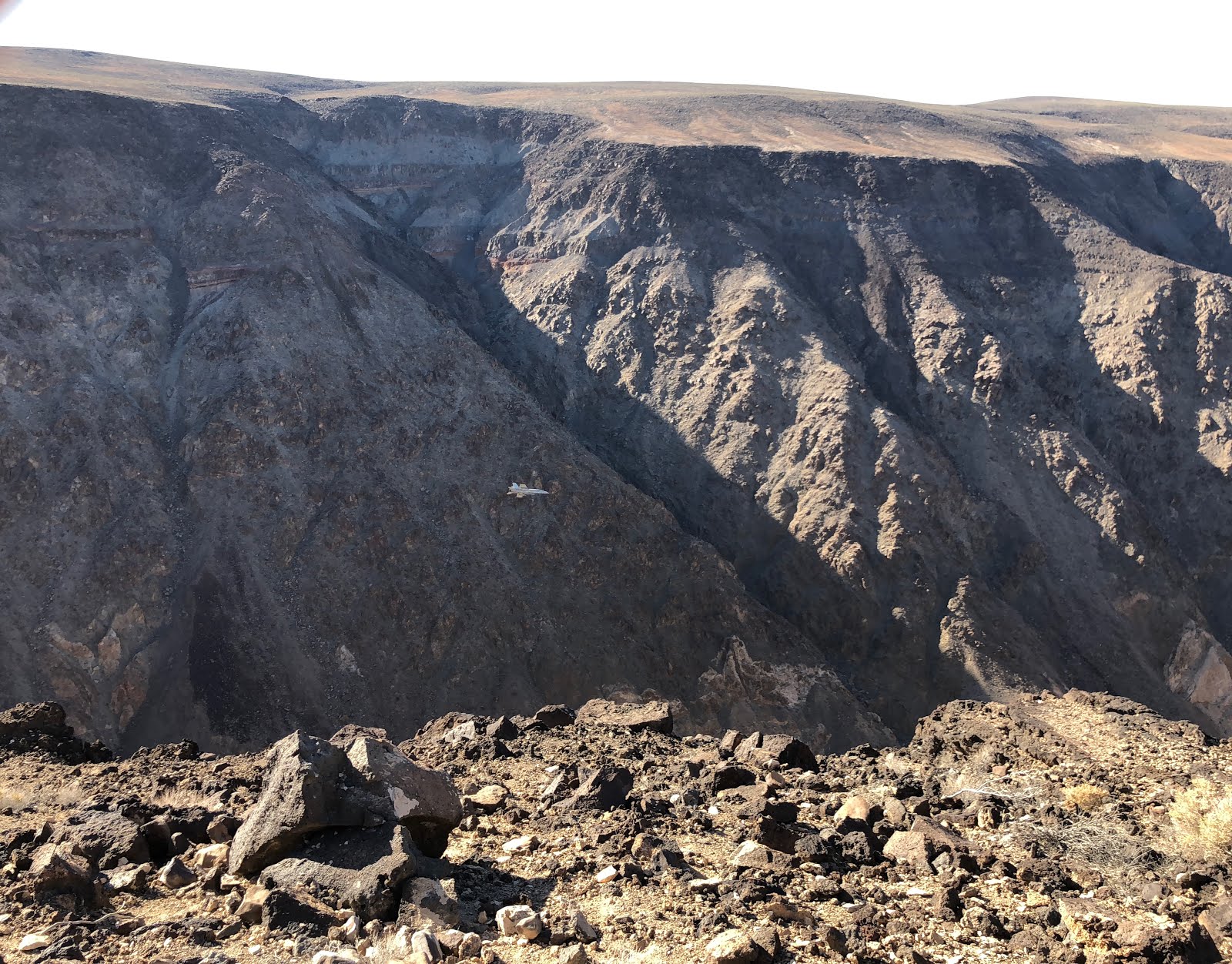
GRAND CANYON NATIONAL PARK
After driving Carrie home, we set off into Arizona. We took a slight detour to drive Old Route 66, stopping to see the Hackberry General Store and getting lunch at Delgadillo’s Sno Cap in Seligman.
Definitely had the charm and feel of old-time Rt 66!
We made it to GC in the afternoon, and it was CROWDED. At least the weather was nice - around 90°, which to us felt totally manageable. The Visitor’s Center doesn’t have too much info (but there are several different museums), so we picked up Jr Ranger books at the store and watched the film. When we went back to get our badges, the GC Association worker who checked us out gave us great tips on where to go, and after we explained our project, he told us about a little-known spot known as Shoshone
Point. It was a sacred site for several Native American tribes, and still used
for ceremonies, weddings, and other rituals.

We stopped first at the Yavapai Geology Museum
(taking the shuttle all the way around since we got on the East instead of
Westbound bus) and learned about the fascinating makeup of the canyon. We got
our first glimpse of the canyon - no matter where you are along the rim, there’s
going to be an amazing view, and each spot is different and unique. But each
spot is also usually crowded, and for the most part you get a great panorama
that spans about 180 degrees.
So it was a complete lucky surprise when we
hiked out to Shoshone Point, a small promontory jutting out into the canyon.
You can see the canyon at least 270° around you - maybe more. We hiked the 1.25
or so miles in, walking as fast as we could to try to catch the last bits of
light - we’d just missed sunset, arriving about 15 minutes too late. But it was
still light enough to truly appreciate what a great vantage we had. We stayed
until after everyone else left, and had the dinner that we’d brought, before
hiking out in the dark. Definitely a lucky and memorable spot!
 |
| Sunset over the Grand Canyon, from Shoshone Point |
TUZIGOOT NATIONAL MONUMENT

It was a ridiculous day today - getting Jr
ranger badges and going on short hikes at FIVE different sites! Granted, they
are all small and in the Flagstaff area, but I’m still exhausted!
The day started early by driving down to
Tuzigoot, an ancient Sinagua pueblo ruin in the Verde Valley. The pueblo has
110 rooms, some 2- and 3-stories, all built of stone on a natural outcrop with
a great view of the valley. It was most likely built between 1100 and 1400CE.
It’s reconstructed, and it is amazing how they did so after seeing the pictures
of the condition they found it in.

MONTEZUMA CASTLE NATIONAL MONUMENT
Near Tuzigoot is another pueblo, Montezuma Castle. This ruin
is very different in feel - it’s 90 ft high on a cliff wall, built into an
alcove, and most likely housed several different families much like a high-rise
apartment. Its location not only keeps it cool during hot summer
months as well as protecting it from annual flooding. Access was from a series
of ladders, that could be removed to keep it safe from intruders.
WALNUT CANYON NATIONAL MONUMENT
 |
| The "island" at Walnut Canyon |
After driving back up through Flagstaff, we
stopped at Walnut Canyon. This site also has cliff dwellings, but these are
more horizontal than vertical, and span both sides of the canyon. The most
interesting section is the Island, built on a limestone cliff on an oxbow
of Walnut Creek.

The back walls and roofs of the dwellings are part of the
cliff, and the view from the front is absolutely breathtaking. We walked down
the 240 steps and around the Island, then back up to the visitor’s center.
SUNSET CRATER NATIONAL MONUMENT & WUPATKI NATIONAL MONUMENT
 |
| Wupatki Ruins |
North of Walnut Canyon is Sunset Crater. We
stopped at the visitor’s center and talked to Ranger Case, who gave us some
great information about the area and the people that lived here. Sunset Crater
erupted about 1000 years ago, chasing away the people who lived here. But when
it erupted, winds blew the ash to the northeast, depositing a rich layer on the
ground that caused the soil to become fertile and trapped water underneath
(which lasted for about 100 years). Because of this, Wupatki was settled between
1100 and 1225-ish. Essentially, Wupatki and Sunset Crater are intricately tied
together; Wupatki wouldn’t exist without Sunset’s eruption.
 |
| Sunset Crater from the Lava Beds |
Also… did you know: A bubble of magma that
slowly rises and hardens without breaking the surface of the earth is called a
pluton - it’s usually a much harder material than the earth around it, so the
surrounding soil erodes away leaving these plutonic hills and mountains. On the
other hand, if the magma bubble breaks the surface, magma turns to lava, and
the resulting mound is a volcano. Plutons are named after PLUTO, Roman god of
the underworld; Volcanoes are named after VULCAN, Roman god of fire.
PETRIFIED FOREST NATIONAL PARK
We spent an entire day at Petrified Forest, a
park that may be named for the petrified trees but is really remarkable
because of its landscape. Half the park is known as the Painted Desert, and
colorful mesas and ‘tepees’ abound.
Ranger Rick, the Chief of Interpretation, has
been helping me with navigating the NPS system and with connecting me to
people, and he introduced me to Ian, an artist-in-residence at Petrified Forest
who was working on a VR project. We just missed him by a few days, but he sent
a great list of places to go for good 360 shots.

We stopped first at the Rainbow Forest Visitor’s
Center, where we walked around the Giant Logs Trail to see up close a number of
petrified logs. 225 million years ago, before the continent of Pangaea broke
apart, the area of Petrified Forest was about 4° north of the Equator. It was a
wet, tropical rainforest, covered in forests, lakes, and rivers. For millions
of year, silt from those waters accumulated, setting the foundation for the
layers found today.
When logs from downed trees were covered by silt from periodic flooding, the
process of petrification began. silica-rich water seeped into the wood, slowly
replacing the organic matter with quartz. Mineral impurities in the quartz give
the petrified logs their different colors. The various flood deposits also
created the colorful layers in the rocks, which are now exposed due to water
and wind erosion. We also saw several bright logs at the Crystal Forest trail.


The landscape at Blue Mesa and the Blue Trees
Trail is absolutely otherworldly - with rich colors in the blue/purple/grey
spectrum. Every time we'd walk past someone on the trail, we'd catch their eye
and we'd all just shake our heads and murmur, "can you believe this?"
in a reverent, disbelieving tone.
 |
| Blue Mesa Trail |
Our next stop was Newspaper Rock, to see the petroglyphs. We could only see
them from above, but there were some very clear figures that could be seen from
the overlook.
Petrified Forest is also interesting because of
the beautiful landscape known as the Painted Desert. Old Route 66 ran straight
through the park, and the Painted Desert Inn was built as a stopping point on
the road for people to get food or spend the night. The inn is now a historic
site, with a great overlook into the Painted Desert.
 |
| The Painted Desert |

Our final stop was Puerco Pueblo, a prehistoric
settlement on the Rio Puerco built by ancestral Puebloan people. More
interestingly, there are lots of petroglyphs in the area, including one of the
sun, which is illuminated by a ray of light from a crack between two rocks that
aligns perfectly during the summer solstice.
Did you know? There are two kinds of rock art:
Petroglyphs are designs carved into rock; pictographs are painted on.
HUBBELL TRADING POST NATIONAL HISTORIC SITE

Hubbell Trading Post is an old Navajo trading
site that was founded by JL Hubbell in 1878 after the Navajo people returned to
the area following the Long Walk. During this stain on US History, the
government forced the native people to leave their homelands and walk to exile
in Fort Sumner, New Mexico. When they returned four years later, their homes
were gone, their crops destroyed, and their livestock slaughtered. Hubbell
helped the Navajo by supplying goods during their recovery. The trading post
was run by the Hubbell family all the way through until it was sold to the NPS
in 1960; it is still considered an active trading post.
CANYON DE CHELLY NATIONAL MONUMENT
Canyon de Chelly is remarkable in that is is one
of the few NPS sites that has a large community of people living in it. The
Navajo people still farm and ranch on the canyon floor, and aside from one
trail, access into the canyon is by permission only.
The park actually consists of two different
canyons, that join together at the entrance of the park. Two rim drives give
excellent overlooks; the South Rim looks over Canyon de Chelly, and the North
Rim looks over Canyon del Muerto.
 |
| Spider Rock |
We started at the Visitor's Center, where we
talked to one of the Park Service police officers, Ranger William. He gave us
his thoughts about the park, but really wanted us to talk to his brother, an
interpretive ranger. So we set off to explore the park before coming back to meet
him.
We drove through the South Rim, stopping first
at Tunnel View for our first glimpse into the canyon. It was surprising to see
how green and lush the floor is; there are thriving farms there, because of a
slowly meandering river as well as a layer of limestone (broken off from the
surrounding cliffs) that trap moisture near the surface.
On our next stop, Tsegi Overlook, we decided on
a picnic lunch. While there, we met a native Canyon de Chelly resident, Corey,
who was just sitting under a tree, "waiting for a ride." We offered
him some food and water, and eventually gave him a ride to his house. We drove
to the end of the South Rim Drive, Spider Rock Overlook. According to Navajo
legend, this is where Spider Woman lives and came down to teach humans how to
weave. We also stopped at Face Rock Overlook and Junction Overlook before
returning to the Visitor's Center to meet with Ranger Justin.
 |
| White House Ruins, from the canyon floor |
Justin is also a Navajo who has lived in Canyon
de Chelly his whole life. The Navajos actually asked the US Government to step
in and help protect the area, which is how the Monument was created. The canyon
floor is almost all closed to visitors unless you have special permission or go
with a licensed guide. The only exception is the White House Ruin Trail, which
goes down to an ancient Pueblo ruin on the valley floor.
That night, we stayed in Chinle - forgetting it
was July 4. Its a small town, and every restaurant we went to was closed... our
choices ended up being Denny's or Churches Chicken. Chicken won.
 |
| White House Ruins, from the canyon rim |
 |
| Mummy Cave Overlook |
 |
| Devil's Backbone, leading to Ship Rock |
The next morning, we left the park via the North
Rim Drive, which follows Canyon del Muerto. There are only 3 overlooks -
Antelope House, Mummy Cave, and Massacre Cave, but they are just as spectacular
as the Southern overlooks and you get a closer look at the Pueblo ruins.
We left Canyon de Chelly via Ship Rock, a
monadnock that rises up in the desert of New Mexico like the prow of a ship,
before heading out to Cortez, Colorado.
 The cliff dwellings at Mesa Verde are spectacular, and we were lucky enough to have several days to enjoy them. While there are over 1200 ruins found, around 600 are dwellings (the others being storage facilities), and only a small handful can be visited. Most require a ranger-led tour, and we got tickets to all four of them - Long House, Balcony House, Cliff Palace, and Mug House. Cliff dwellings are primarily made up of sandstone, mortar, and wooden beams. The sandstone blocks were shaped by chipping at them with harder granite collected from river beds. Mortar was made with soil, water, and ash, and smaller stones were fitted into the gaps in the mortar to add stability to the walls.


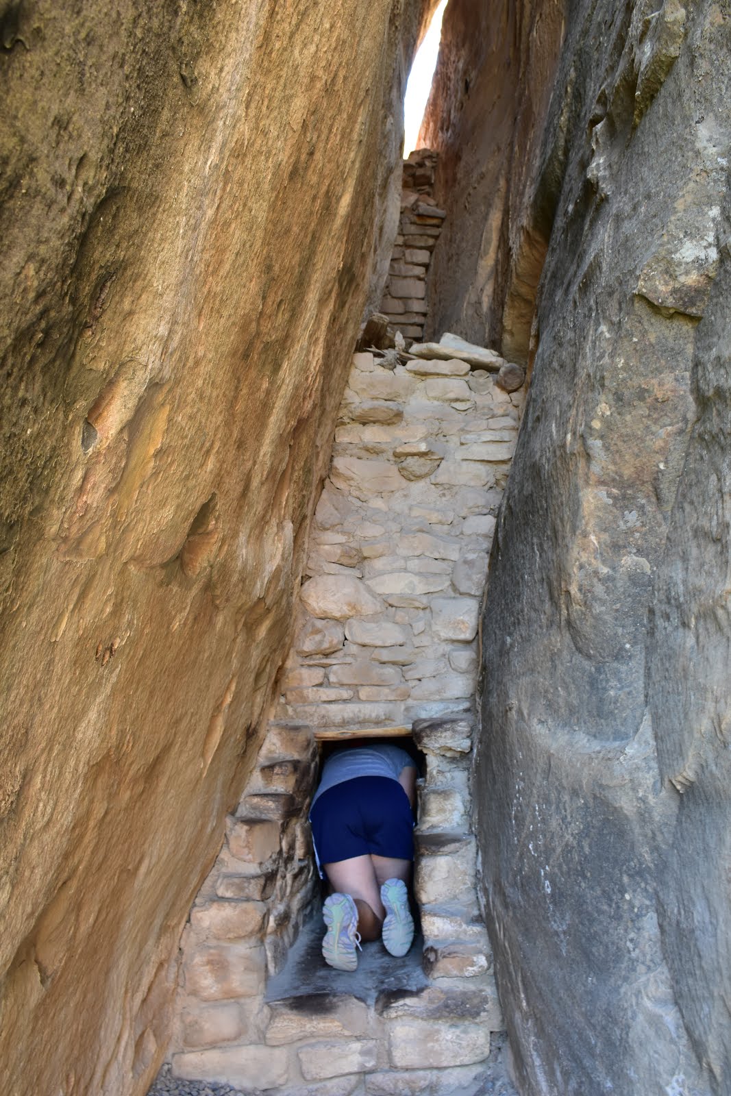


 On our final day, we took the Mug House tour - a backcountry hike to one of the lesser-visited cliff dwellings. It was a small group of only 10 visitors, and the trail was more scrambling over boulders and dodging rare endemic plants. Along the way, we passed by two other alcoves - one of which had a good example of a pictogram, a long zigzag that was compared to the Aztec god Quetzalcoatl. To me, it looked more like a mountain range... but I guess that's why I'm not an archaeologist...


 The next stop, which we did as a bit of an afterthought, was to Painted Hand Pueblo. This was an unexpected find down a bumpy dirt road, with a 13th century tower perched on a rock overlooking the canyon. Underneath was a small alcove, with several pictograph handprints painted on the back of the rock wall.
 The final stop of the day was to Hovenweep, where we walked the Square Tower Loop. This cluster of ruins was the largest group of Hovenweep's groups, housing up to 500 people between 1200 - 1300CE. We walked around Little Ruin Canyon, stopping to see the many structures that were perched on the canyon rim, tucked into alcoves, or built on and around boulders.