Finally, the Parks and Rec Trek has begun!! It has been a crazy past three days, but we’re having an amazing experience and have gathered a ton of great info.
Packing for the trip was a huge endeavor, namely because I was super worried about the temperature inside the car. Leaving things like electronics or lotion might not be a great idea since the outside temperature in places like Death Valley can sometimes reach 120 - meaning a baking car temp of 150-170. We have an entire cooler just for electronics, and another specifically for medicines/extra sunscreens/etc. With the addition of three sleeping bags, there isn’t a ton of room in our enormous Beast of a GMC Yukon.
YOSEMITE NATIONAL PARK
We picked up Carrie, who is joining us for the first five nights, on our way out to Yosemite. Carrie is a middle school science teacher from Oakland, who I met a few years ago at a teacher conference. In exchange for crashing the trip, Carrie is going to help us with writing curriculum and coming up with lesson ideas.
 We drove straight through to Wawona, making it exactly on time for our 1:30 meeting with Ranger Alejandra. Alejandra gave us some great tips for places to go (some that we hadn’t thought of, like the top of Sentinal Dome) as well as telling us about moon bows.
Our first sightseeing stop was Mariposa Grove - the grove of giant sequoias that had been closed for 3 years for upgrades. It had opened the week before, so we were one of the first to enjoy the new trails. Did you know - a giant sequoia is considered “mature” only after is has reached 800 years of age? And in the Mariposa Grove, there are over 500 mature sequoias!!
The other interesting fact we learned was that almost the entire park used to be covered by glaciers… but not Mariposa Grove. So that’s why there are so many really old trees that still remain.
 |
| On top of Sentinel Dome |
Mariposa Grove is in the Wawona area of the park, and we drove from there to Glacier Point for a nice overlook of the valley. The lighting unfortunately came out really hazy, and looking back maybe because of smoke from the nearby Lions Fire. Even so, we enjoyed the view and decided to take the time to hike up to the top of Sentinel Dome.
It’s strange how many domes are in Yosemite - and it turns out, there are two types. One, like the one right outside Tuolumne Meadows, is formed by glaciers - usually gradually sloped on one side with a steeper dropoff on the other. This is caused when the glacier slowly shears the rock as it climbs up, then quickly falls off the back side. The other type is a exfoliation domes - like North or Half Dome. These were once covered with ice which went away, but seeped in and fractured the existing rock with then peeled away like an onion, leaving a dome.
From the top of Sentinel, we could see all around the valley - from Vernal and Nevada Falls and Half Dome to the East, across to Yosemite Falls and El Capitan.
We then drove down to the valley, stopping for a quick photo at Tunnel View. After checking in and having dinner, we went straight to Lower Yosemite Falls to see if we could catch the moonbow.
You know that Sunlight + Rain (or moisture) = Rainbow…..
 |
| Moonbow at Lower Yosemite Falls |
But did you know that Full (or nearly) Moon + Waterfall = MOONBOW???
You can’t see a moonbow w/ the naked eye unless you have near-perfect conditions (very bright moon, lots of water, and high winds) - which we did NOT have, but we caught it on camera with a long exposure.
Didn’t get to sleep until around midnight, but it was overall a great day!
The next morning, woke up with the sounds of others in the tent cabins around us. We drove around the valley floor and found a picnic area at Cathedral Beach, where we had breakfast and worked on our junior ranger booklets. We drove around the valley looking for good places for 360 shots - it was difficult with a really bright sun, but we got some good views past Sentinel Bridge. Shows how wide the valley is, with fairly straight walls for sides. Usually, glacial valleys are “U” shaped and valleys formed by rivers are “V” shaped. The reason why Yosemite doesn’t have a curved bottom is because there is 1000(??) feet of sediment filling in the U, so there is a wide, flat meadow on the valley floor.

Our next stop was Tuolumne Meadows, so we drove up and out on Hwy 120. We stopped at Olmstead Point for a look down into the valley - it looks back on Half Dome, and a volunteer had set up a spotting scope to see the line of hikers climbing up the ropes. She also had pictures of the line from before the institution of the permit lottery, and it definitely seemed like the lottery made it much more manageable.
There was a short hike out to the overlook, on top of another dome, for a look back at the eastern entrance of the valley.
From there we drove to the Tuolumne Meadows Visitor Center, where we got our junior ranger badges and talked to Ranger Kaleb, who gave us some great info on the formation of the valley and domes.
We had lunch on the hike out to Soda Springs, where natural mineral water still seeps out of the ground. Even geologists don’t know why these small spring are where they are. Its located by Parson’s Lodge, a meeting hall built by the Sierra Club. It’s also near the site where John Muir and his friend first discussed how to preserve and protect the area. A year later, Yosemite National Park was founded.
DEVIL’S POSTPILE NATIONAL MONUMENT
 On the Eastern side of the Sierra Nevadas is Devil’s Postpile, a columnar basalt formation created almost 100,000 years ago. Glacial moraines had formed a dam that stopped a flow of hot lava, creating a 400-foot deep pool. When it cooled, cracks formed at the top and bottom of the pool to release built-up tension. The cracks turned into hexagons (because nature loves 120 degree angles), and traveled through the cooling lava until the columns were formed. But they were still hidden until the last ice age 20,000 years ago cam along and a glacier exposed the cliff. Along the top of the Postpile, you can see the striation marks caused by the carving glaciers.
Getting to the monument took a few tries - you have to take a shuttle from the Mammoth Ski Resort, and after getting some wrong information about where the visitor center was (there isn’t one), we barely made it onto the next bus up to the monument. We made it to the Ranger Station with about 20 minutes to spare, and got some great information from Ranger Monica. She was even nice enough to give us our Junior Ranger patches, even though we weren’t finished with our booklets, and the other ranger let us buy a pin and patch even though the store was technically closed.

On our way back on the shuttle, we chatted with a guy who was doing the Pacific Crest Trail and gave him a ride down into Mammoth Lakes. He started on the Mexico border on April 24 and still had about 5 months to go. He’d done the Appalachian Trail last year and was planning on tackling the Continental Divide next year… quite an interesting lifestyle!
MANZANAR NATIONAL HISTORIC SITE
 After a morning of trying to fix our rental car (several calls to multiple Enterprise numbers, a visit to Firestone, a visit to Enterprise Bishop, more phone calls, and a promise of a call back) - resulting in us having a car with no brake lights for the next 3 days - we finally made it to Manzanar. We started in the visitor’s center, where we worked on our Junior Ranger badges, watched the film, and learned about individual stories.

Today, there are three original buildings left standing - after Manzanar closed, most of the structures were sold off by the US government. In Block 14, there are reconstructed barracks, a latrine, and mess hall where you can see the challenging lifestyle people had to endure. The rooms were stifling hot, and a constant wind blows dust and dirt through cracks and windows. In the latrine, communal toilets and showers meant absolutely no privacy; in the mess hall, food was cooked in bulk and not suited to Japanese tastes.
 We took the driving tour around the site, stopping first for lunch in some shade, then at Merritt Park to see the remnants of what was once a beautiful oasis with lawns, bridges, a pond, and flower gardens. Our final stop was at the shrine in the cemetery, where people have left hundreds of origami cranes. Some were faded to almost a colorless grey; others were vibrant and rainbow-hued.
 DEATH VALLEY NATIONAL PARK

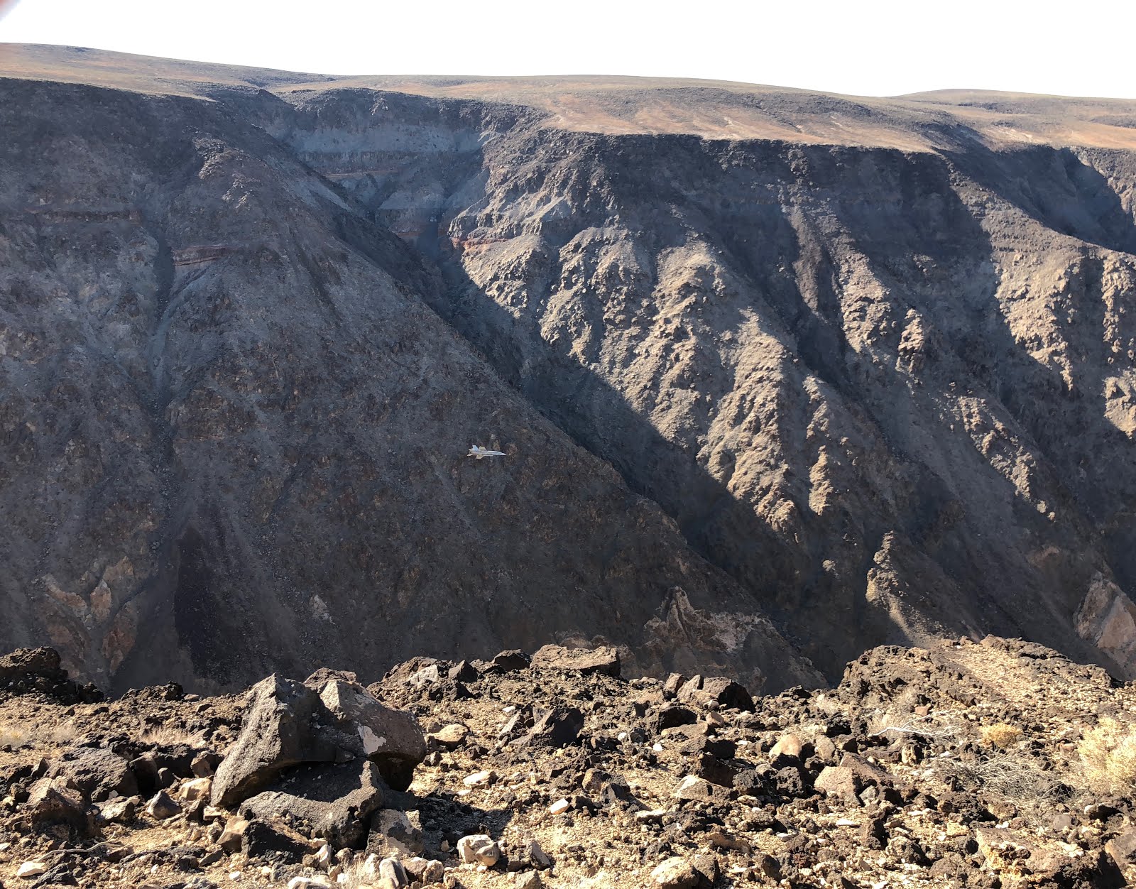 I’d heard of this place (but forgotten it) - known as Star Wars Canyon, the military uses the area for low altitude maneuver training. It is always a hit or miss whether you’ll see a fighter jet - some days, there are none, but that day they had already seen 16 (the man I was talking to had been there since 5AM!!) We all doubted we’d see one, but it was so interesting talking to them - the fighter pilots call the maneuver into the canyon and out into the valley the “Jedi Transition,” and from the vantage point that we were standing, you could see almost the entire length of the route. We chatted for about 40 minutes and were just getting ready to leave, when suddenly Dave saw a speck in the horizon approaching - it was an F-18 Hornet fighter jet, coming in for a pass.
  |
| Thanks, Bo, for the close-up pic of the F-18! |
That night, Dave and I tried to take a few pictures of the full moon, but failed spectacularly…
 |
| Meeting w/ Ranger Brandi |
The next morning, we had a 9AM meeting with Ranger Brandi in the Furnace Creek Visitor’s Center. We left at 7:30 and by the time we got to the VC it was already 104°. Brandi had good info - about the formation of the valley and why it stays so hot, as well as ideas on things to focus on (Badwater Basin and the salt flats was her “can’t miss” location, since it is unlike anywhere else in the world.)
We earned our junior ranger badges, then set out to explore the park.
 First up was Badwater Basin, the lowest point in North America at 282 feet below sea level. We walked out into the salt flats and took a detour to get away from the crowds - found an area with new salt and lots of wet ground. Can easily see how the area is close to the level of the aquifer. The water was originally from Ice Age snow and rain that travelled hundreds of miles from central Nevada. The bedrock is a porous limestone, and the aquifer ends along a faultline at the base of the mountain at Badwater. Salts from old deposits combine and flow down, ending at the lowest elevation. When the water evaporates, it leaves the concentrated minerals. It’s named Badwater that because a prospector couldn’t get his mule to drink from the water, so he wrote on his map that the spring had “bad water.”
  |
| Devil's Golf Course |
Devil’s Golf Course was formed by crystallized salts, shaped by winds and rain. This area, along with Badwater, really show how many minerals are present in the area.
 |
| Artist's Palette |
Artist’s Drive/Artist’s Palette is maybe my favorite place in Death Valley. It truly is a palette of colors - pinks, oranges, yellows, and blues all on the same area of rock. The colors are formed by different minerals caused by variations in oxygen levels and elements present when volcanic eruptions 5 million years ago first deposited the ash and minerals that make up the mountain. The minerals include iron, aluminum, magnesium, and titanium, as well as red hematite and green chlorite. Surprisingly, there is no copper here even though there is a greenish blue that looks just like that of a copper dome!
 The Keane Wonder Mine was one of very few profitable gold mines in Death Valley, running from 1904 to 1917 and producing over a million dollars in gold. They even used some of the gold mined here to make coins to pay their employees!
 |
| Ubehebe Crater |
The Ubehebe Crater is actually an explosion crater, formed when a superheated combo of steam and rock explodes to create a crater. It’s actually fairly new, at around 2,000 years old. Makes you wonder what kind of volcanic activity is going on under us right now, and whether anything else is getting ready to explode!
 |
| Golden Canyon at sunset |
Since we were in the valley already anyway, we had dinner at the diner in Furnace Creek and went on an evening hike up Golden Canyon.
This is one of the most popular hikes in Death Valley; back in the day, it used to be paved and people could drive up to see the canyon; now, only some of the pavement remains. We started a little after 7pm, but is was still over 100° out. We hiked about half a mile in, having much of the hike to ourselves which made for some good 360 photos.
On our way back, we saw both bats and a kit fox on the side of the road!
 |
| Sidewinder rattlesnake tracks |
We also found what we think are tracks from a kangaroo rat, roadrunner, stink bug (or some other beetle), and kit fox (or other small canine). We also found the burrows of what we think are a kangaroo rat and a sidewinder (based on the number of tracks right outside.
 |
| Mosaic Canyon |
We then stopped at Salt Creek (where, in the spring, you can find pupfish) - but it’s now dried up. Dozens of zebra lizards, very white to camoflage themselves on the dried creekbed, dart around or stand with their bodies far off the ground to stay of the hot hot sand. There were also giant Western horseflies - about 3/4 of an inch long, that bugged us (haha, see what I did there?) the whole time - one even bit Carrie through her shirt.
 |
| Harmony Borax Works |
Our next stop was Zabriskie Point, where we could see the colorful badlands down into the valley. The clay, sandstone, and siltstone buildup from a long-ago lake used to be flat, but seismic activity and pressure folded up the valley floor, and periodic rainstorms caused gullies in the eroded soft rocks.
20 miles up from Zabriskie is Dante’s View, overlooking Badwater Basin and the rest of the valley. It was named purely as a PR move for tourism, but it is definitely a great panoramic overview of the entire Panamint Range.
 |
| The view from Zabriskie Point |
 |
| Badwater Basin from Dante's View |
We’re now in Henderson/Las Vegas, and will be dropping off Carrie tomorrow before heading out into Arizona!